
When responding to an oil spill, it’s important to get a look at the spill from every possible angle — both from land, from sea, and even, from space. Oil spill response teams in federal and state governments face challenges in offshore surveillance, simply due to the lack of observations over open water (compared to land).
Deepwater Horizon is arguably the most high profile oil spill to have occurred in the U.S., but what’s little known is that dozens of small, human-caused oil discharges happen in U.S. waters every single day – and there are likely many more that go undetected and unreported. Underwater pipeline leaks, damaged platforms, equipment failures, sunken vessels — there are many possible sources for small discharges. There are even intentional oil discharges, in which vessels illegally release their oil waste at sea instead of paying to have it properly disposed of in port. This act is a violation of MARPOL 1978, the International Convention for the Prevention of Pollution from Ships.
Oil spills can be tough to spot if someone’s not looking in the right place — especially for small discharges. That’s why, at the request of NOAA’s Office of Response and Restoration, the NOAA Satellite and Information Service, Satellite Analysis Branch (SAB) established a 24/7 satellite-based Marine Pollution Surveillance Program. The program became fully operational in 2011 to leverage openly available environmental satellite imagery to surveil U.S. waters.
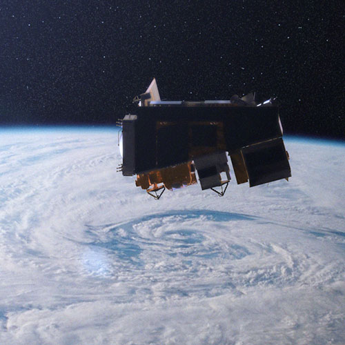
Prior to 2011, there wasn’t a dedicated effort to perform routine satellite monitoring for oil spills in U.S. waters. In the past, during large spills, satellites have been used for remote sensing to view the full extent of a spill. During Deepwater Horizon, the spill was so large that overflights weren’t enough to view the entire impacted surface area. NASA’s Terra Satellites, however, offered a big picture view of the situation.
The new marine desk in the Satellite Analysis Branch took remote sensing capabilities a step further, and was tasked with more than just looking at major spills as they came up. SAB’s Marine Pollution Surveillance Program mission is twofold — to provide satellite support for oil spill emergencies declared by OR&R’s Emergency Response Division, and to routinely monitor for marine anomalies that are believed to be the result of an accidental or intentional oil release, and report their findings to federal and state agencies. In other words, with the inception of this new branch, NOAA began searching for oil spills that have yet to be reported, in addition to those that OR&R is already responding to.
To accomplish this, the analyst scans a combination of high resolution visible imagery and Synthetic Aperture Radar to look for possible oil. Visible imagery is advantageous because different color combinations can be analyzed to distinguish oil from vegetation. Radar imagery is advantageous because it can “see” the surface of the ocean during night time hours and through clouds.
The analysis is currently a manual inspection of the satellite imagery, but the program is evaluating the performance of an automated oil detection algorithm. When a suspicious anomaly is identified, it’s compared against a wide array of ancillary information to rule out false positive signatures and naturally occurring features. Overlays include the locations of oil production platforms, pipelines, well heads, bore holes, natural seeps, and shipwrecks. Environmental information is also consulted, which includes surface winds, ocean currents, and bathymetry.
Since the analysis is a subjective interpretation, the visual characteristics of the anomaly itself must meet specific criteria in order to be reported as possible oil in a Marine Pollution Surveillance Report. The confidence criteria was developed in-house and is jointly based on peer reviewed literature and ground validation from the responders on scene.
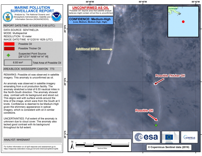
A surveillance report is typically produced within six to 12 hours after the images have been received. As seen in the image above, the left side contains text details including the report date, report time, satellite sensor, spatial resolution, image, date, image time, coordinates, total area of possible oil, a remarks section, and an uncertainties section. The right side displays a close up view of the possible oil anomaly, corresponding annotations, a map inset, and the confidence assessment.
Approximately 200 surveillance reports are produced each year, with that number growing as more satellite imagery becomes openly available, and as detection capabilities improve.
In addition to monitoring for oil spills, SAB also monitors for marine debris on an event-driven basis. The program first started investigating the capability of debris detection after the Japanese tsunami in 2011 and found that large debris rafts are easily spotted. For smaller plastics, however, even the highest spatial resolution that’s currently available isn’t enough to positively identify them.
The capabilities of SAB and other monitoring programs continue to grow, particularly as collaboration is made possible. On May 2, 2018, an agreement was reached with Canada’s oil spill monitoring program, Environment and Climate Change Canada’s Integrated Satellite Tracking of Pollution, for collaborative activities. This joint effort is a major asset due to the Canadian agency’s expertise in ice as it relates to oil spills.
Marine Pollution Surveillance Reports became a publicly available product as of March 2018 and can now viewed at the NOAA Office of Satellite Products and Operations website.
This guest blog was written by Ellen Ramirez, a physical scientist in the NESDIS Office of Satellite and Product Operations, Satellite Analysis Branch. SAB has been around for more than 50 years, with operational desks covering heavy precipitation and snow, wildfires and smoke, tropical cyclones, volcanic ash, and most recently, oil spills. Ellen is the operational lead for the marine pollution product area, managing a team of 10 analysts that identify accidental and intentional oil discharges in U.S. waters, and subsequently issue pollution reports.