
This blog was originally published on April 21, 2020.
On April 20, 2020, NOAA will join our state and federal partners in observing 10 years after the Deepwater Horizon oil spill — an incident that resulted in the tragic loss of human life and an unprecedented impact to the Gulf’s coastal resources and the people who depend on them. From March 30 to April 20, tune in as we go back in time to the day of our country’s largest marine oil spill, what’s happened since then, and how we’re better prepared for future spills. In our final blog we provide on overview of some of the advances in science we’ve discussed in-depth throughout the last three weeks.
1. Improvements in Oil Spill Modeling
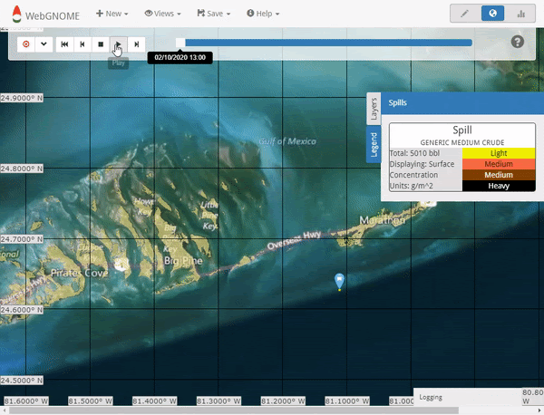
During the Deepwater Horizon spill response, NOAA experts used their workhorse oil spill trajectory model, GNOME, to develop hundreds of forecasts to estimate where the oil from the gushing wellhead would end up.
Today, the program has expanded into GNOME Suite which can be used and accessed in multiple ways. These tools allow for better visualization of the trajectory and fate of oil, allow for more complicated and automated trajectories for statistical analyses, the integration of an oil spill blowout model, rapid review of toxicity and fate information for oil, dispersants, and chemicals, and enhanced interaction with GIS and other mapping systems.
Finally, the GNOME development team made all the code open-source through GitHub, creating a community model that welcomes others to use and contribute, providing transparency and encouraging collaboration within the oil spill modeling community.
2. New Technology Patrolling America’s Oceans for Pollution Using Satellites


The Deepwater Horizon oil spill emergency launched a fledgling satellite mapping program into action. The daily composite product, pictured left, in particular became a vital tool and the topic of national attention.
In the 10 years since, NOAA’s Marine Pollution Surveillance program has grown to monitor America’s waterways for accidental or intentional oil spills. Its advances with oil spills are evident in our monitoring abilities, slick detection and characterization techniques, and the widespread use of NOAA’s tool at all levels of government.
One of the biggest advantages of these oil spill maps is that they can be published in near real-time and are available for the public online. By logging on you can view the most recent oil slicks detected in U.S. waters as a downloadable report, or as an interactive web map.
3. Classifying oil spill thickness with research born from Deepwater Horizon


The 2010 Deepwater Horizon oil spill required the use of brand-new satellite technology to detect and map the footprint of oil on the surface of the ocean. A decade later a team of interdisciplinary scientists, many of whom worked on the historic spill, are developing ways to advance satellite technology to do something new -estimating the thickness of oil slicks from outer space.
A recent paper in Remote Sensing of the Environment outlines innovative methods to use satellite technology to measure the thickness of floating oil, then deliver these data to responders faster than ever before. This allows scientists to zero-in on the thick “actionable” oil that can be best cleaned up or contained.
4. Advances in Oil Toxicity Science
, and a larva exposed to Deepwater Horizon crude oil as it developed in the egg (bottom). The oil-exposed larva shows a suite of abnormalities including excess fluid building up around the heart due to heart failure and poor growth of fins and eyes. Image credit: NOAA.")

Assessing the impacts of Deepwater Horizon required a comprehensive program to evaluate the toxic effects of the spilled oil, including numerous laboratory studies to support habitat-specific work in the field.
Through this comprehensive toxicity testing program, NOAA and our partners created an unprecedented, large, and coherent dataset to draw conclusions about how the Gulf of Mexico natural resources were injured by the BP oil spill. We also made all of these data publicly available and published them in the scientific literature so that other scientists could benefit from and leverage this work.
5. Understanding how Oil Impacts Deep Sea Corals
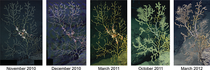
Deep-sea corals live for hundreds to thousands of years, and their deaths are rare events. Remotely Operated Vehicles (ROVs) were sent 4,500 feet down to examine the impacts of the oil spill. They found many colonies were partially or entirely coated in clumpy brown floc, which contained petroleum droplets with similar chemical markers to Deepwater Horizon crude.
A study published in 2014 found that observed impacts to life in the deep ocean are closely tied to the Deepwater Horizon oil spill, and the full extent of the harm (and eventual recovery) may take years, even decades, to manifest.
6. Dolphin Discoveries that Help Prepare for Disasters


Assessing the impacts of the spill on marine mammals in the wild is a complex task and can require years of ongoing study to understand how exposed animals are recovering. Since 2015, NOAA experts have partnered with scientific leaders from a diverse range of backgrounds to continue studies to determine how dolphins and large whales were impacted by the spill.
These advances range from tools like ultrasounds, blood tests, immune system diagnostics, and x-rays that allow scientists to study dolphins efficiently and effectively, to technologies that use Artificial Intelligence to identify individual animals from photos, and new guidelines for oil spill response and assessment.
7. Advances in Assessing Sea Turtles and Marine Mammals During Oil Spills


Learning from the response to the Deepwater Horizon and other spills, marine mammal and sea turtle scientists have joined with oil spill experts to document lessons learned regarding the best ways to protect, rescue, assess, and restore sea turtles and marine mammals impacted by oil. This information has been distilled into two NOAA technical memos:
- Guidelines for Oil Spill Response and Natural Resource Damage Assessment: Sea Turtles.
- Guidelines for Assessing Exposure and Impacts of Oil Spills on Marine Mammals
These documents provide practical guidelines for oil spill, marine mammal, and sea turtle experts to prepare for and quickly respond to oil spills that might impact these protected species.
8. Using Deepwater Horizon Data Tools to Protect America’s Coastal Resources
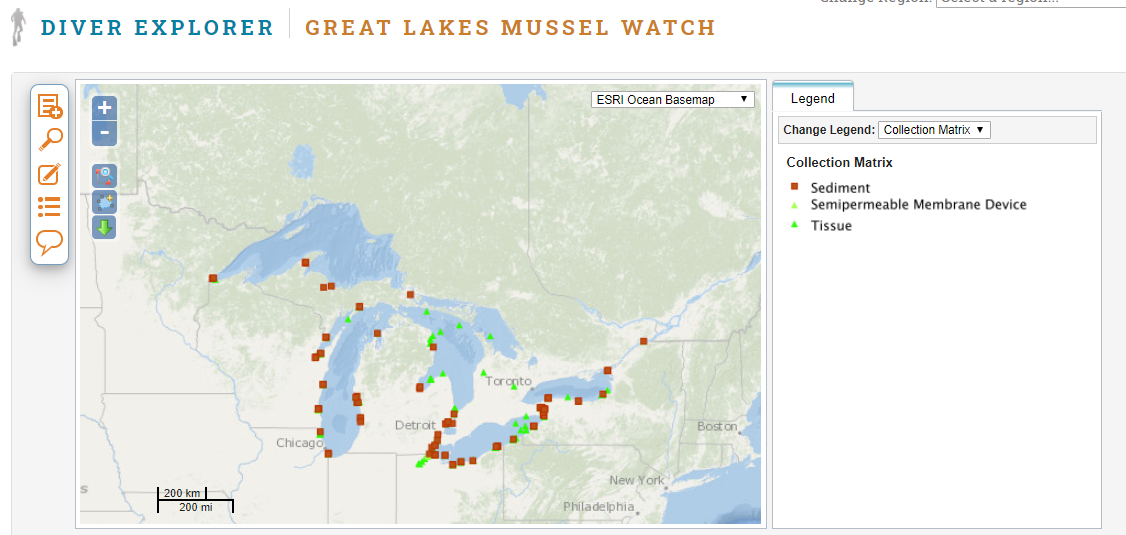
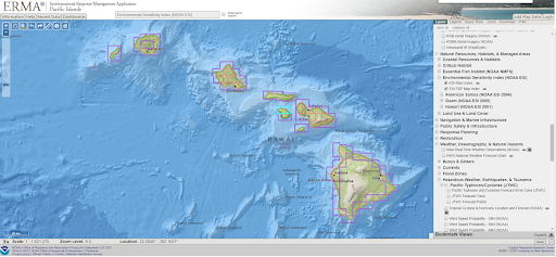
The volume of scientific data collected in the wake of Deepwater Horizon was unprecedented, requiring new and improved tools to house and display this information for responders, researchers and the public. These tools include:
ERMA (Environmental Response Mapping Application): ERMA is an online mapping tool that combines both static and near real-time data in a centralized, easy-to-use tool for environmental responders and decision makers
NOAA’s DIVER (Data Integration, Visualization, Exploration, and Reporting): DIVER is a massive warehouse that allows users to search through, visualize, and download huge amounts of data on environmental pollution.
In the 10 years since DIVER was created and ERMA was adapted for Deepwater Horizon oil spill data, these applications have grown into critical tools for NOAA’s work around the country.
Deepwater Horizon challenged the spill response community and sparked a need for advances in science to help us prepare for future oil spills. In the decade since this tragic event, NOAA has enhanced its science, technology, and communication for the better, using the multitude of lessons we learned during Deepwater Horizon.