
Sixty years ago, on March 27, 1964 at 5:36pm local time, (March 28 at 3:36 UTC), a 9.2 magnitude earthquake struck the Prince William Sound, Alaska region. The “Good Friday earthquake” was and still is the largest U.S. earthquake ever recorded and the second largest recorded worldwide. The epicenter was 75 miles east of Anchorage and the earthquake was felt over a large area of Alaska and in parts of western Yukon Territory and British Columbia, Canada.
Alaska’s continental shelf and North American plate rose over 30 feet during the earthquake. This sudden displacement of the ocean floor, along with earthquake-induced landslides, generated massive local tsunamis. Two hundred miles southwest, some areas near Kodiak were permanently raised by 30 feet. Southeast of Anchorage, areas around the head of Turnagain Arm near Girdwood and Portage dropped as much as eight feet. These seafloor changes had long-term economic and ecological effects, and much of the region had to be recharted to ensure safe navigation.
The Impacts in Alaska — and down the Pacific Coast
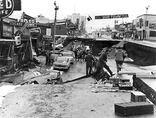
In Prince William Sound, Port Valdez suffered a massive underwater landslide, resulting in 32 deaths in that port. The docks, warehouses, and canneries of Valdez disappeared, sweeping away men, women, and children. Nearby, a 27-foot tsunami destroyed the village of Chenega, killing 23 of the 68 people who lived there. Multiple post-quake tsunamis severely affected Cordova, Whittier, Seward, Kodiak, and other Alaskan communities.


In Seward, the earthquake ruptured oil tanks that were set ablaze. When the tsunami arrived, it created a wave of fire that expanded its path. (Following the earthquake, towns such as Seward, Valdez, and Chenega were moved to safer ground.)
In addition to the loss of many fishing vessels, canneries, and other processing plants, many fish populations were affected. Cordova was the world’s largest razor clam fishery. After the earthquake, the seabed around Cordova rose eight feet and destroyed the clam fishery.
President Lyndon Johnson declared the entire state of Alaska a major disaster area a day after the earthquake.
Impacts were not limited to Alaska, however. British Columbia, Washington, Oregon, and California all suffered damage. Waves more than 14 feet above tidal height flooded 29 blocks of Crescent City, California, and killed 11. Further north, four people in Newport, Oregon, also perished from the waves. The tsunamis caused damage as far away as Hawaii and Japan.
How Might it be Different Now?
Now, 60 years later, there are different considerations for how the U.S. should respond to a similar disaster. Alaska is a seismically active area and has had other smaller earthquakes since the Great Alaska earthquake, but Alaska is very resilient. An 8.2 magnitude earthquake occurred in 2021 along the sparsely populated Chignik region of the Alaskan peninsula. No casualties or serious damage were reported. Years earlier, however, a 7.1 magnitude earthquake hit the Anchorage area in 2018, injuring 117 people and causing $76 million in damages.
Additionally, Alaska has changed and grown since 1964. Then, the total population of Alaska was just 250,000. The largest city was Anchorage, with a population of 100,000. Today, Alaska’s population is over 730,000 and Anchorage’s is 288,000.
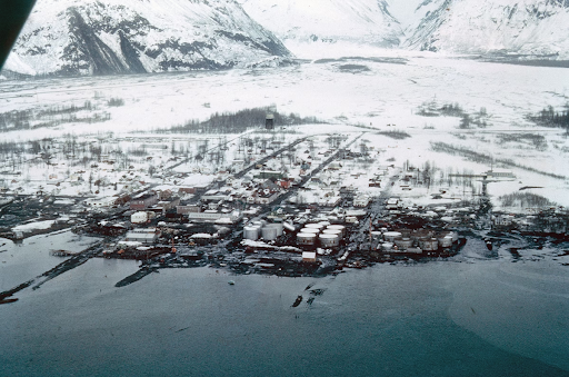
Valdez had a population of 1,200 in 1964. The tsunami wave run-up was as high as 170 feet. Half of the downtown business district was demolished, massive damage was caused to the waterfront, storage, warehousing and railroad facilities. The town's entire fishing fleet was also destroyed.
Commercial fishing fleets in Central and Western Alaska have also grown, and while some of the communities were relocated, the harbors are still vulnerable to tsunamis. South Central and Southeast Alaska are also now major tourist destinations. Over 40 cruise ships visited Valdez alone last year. The cruise calendar extends from April through October.
The threat from earthquake-triggered landslides, debris flows, and locally generated tsunamis are under growing scrutiny. Degrading permafrost, retreating glaciers, and changing climates are expected to increase these threats.
Adding Oil to the Mix
The oil and natural gas industries are a key part of Alaska's energy-intensive economy. Alaska’s North Slope contains six of the 100 largest oil fields in the United States and one of the 100 largest natural gas fields. The Prudhoe Bay field is among the 10 largest oil fields in the nation.
Today, Valdez is the southern terminus of the Trans Alaska Pipeline and, with a population of around 4,000, handles the shipment of Alaskan North Slope oil to the rest of the U.S. Huge oil storage facilities are located along the harbor.
The state currently has five oil refineries capable of producing a combined 167,000 barrels per day. Between January 2023-2024, Alaska produced 171,458,547 barrels of crude oil, and averaged 350 billion cubic feet of natural gas annually.
NOAA Planning and Preparation
While the systems to respond to environmental emergencies were limited decades ago, today, the Emergency Response Division (ERD) of NOAA’s Office of Response and Restoration, or OR&R, provides scientific support and decision-support tools to respond to damage to oil and energy infrastructure along the coast, resulting from a major earthquake.
ERD uses its collection of software and GIS tools to respond to spills resulting from damaged oil and chemical infrastructure after a major earthquake. Examples include General NOAA Operational Modeling Environment (GNOME), NOAA’s suite of modeling tools for predicting the fate and transport of pollutants spilled in water, and the Environmental Response Management Application (ERMA®), an online mapping tool that integrates data (like habitats, weather, and currents) into one location for experts who are responding to environmental disasters. OR&R also develops planning tools, such as the Trajectory Analysis Planner (TAP) and Environmental Sensitivity Index (ESI) maps and data to help state and federal partners prepare for a major spill before it happens.
Over the past 10 years, ERD has assisted Alaska in responding to 188 spills in Alaska, mitigating the impacts of 3.9 millions of gallons of oil to the region's sensitive environmental resources, critical fisheries, and coastal communities. As new challenges come on the horizon—such as container spills, shipboard fires from lithium ion batteries, Low Sulfur Fuel Oil spills, releases of compressed gas transported by rail, and dielectric fluid spills—ERD is preparing to meet those new response needs in the future.
Resources
NOAA National Centers for Environmental Information: On This Day: Great Alaska Earthquake and Tsunami
U.S. Geological Survey: M9.2 Alaska Earthquake and Tsunami of March 27, 1964
The Atlantic: 1964: Alaska's Good Friday Earthquake
SFGATE: The day in 1964 when a tsunami ravaged Crescent City
Alaska Department of Natural Resources: Division of Oil and Gas: All Pipelines
U.S. Energy Information Administration (EIA): Alaska Profile Analysis