Posts tagged with

Mapping

Unveiling An ERMA Update: New Tools, Improved Layout, and More

Posted Tue, 02/20/2024 - 11:16
By Jay Coady, Office of Response and Restoration

This month, NOAA’s Office of Response and Restoration released a new version of the Environmental Response Management Application (ERMA®). The latest release of the web-based mapping application used by environmental responders and natural resource decision-makers includes a host of new features, tools, and optimizations, as well as improved mobile device responsiveness.  

Tags

How California Oil Spill Responders Use NOAA's Mapping Tools to Track Resources at Risk

Posted Thu, 05/12/2022 - 17:25
By Shane O'Neal, Office of Response and Restoration, and Greg McGowan, California Department of Fish and Wildlife’s Office of Spill Prevention and Response

When you think of California, some of the first things that come to mind might be sandy beaches, surfing, or sea otters floating in the kelp beds off the coast. It makes sense—the state has 3,427 miles of tidal shoreline! Along with these wild and wonderful natural resources, many important human resources line the coasts of the Golden State as well. Protecting these resources over thousands of miles is a tough job, but the first step is knowing what is there to protect. 

How OR&R’s Partners in Florida Use Environmental Sensitivity Index Maps and Data

Posted Fri, 02/25/2022 - 13:35
Shane O'Neal, Office of Response and Restoration, and Timyn Rice, Florida Fish and Wildlife Conservation Commission, Fish and Wildlife Research Institute.

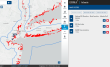
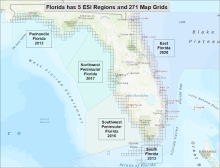
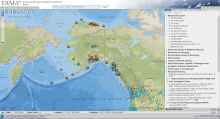
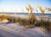
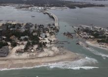
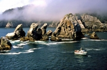
The state of Florida has the most coastline of any in the contiguous United States, from sandy beaches to subtropical islands, estuaries, mangroves, and everything in between. Protecting these critical coastal resources is a major task, and NOAA’s Environmental Sensitivity Index product is a crucial tool in the state’s belt. 

Are We Prepared for Oil Spills at Niagara Falls and Mackinac Island?

Posted Wed, 03/03/2021 - 20:52
By Megan Ewald and Donna L. Roberts, Office of Response and Restoration

Over 8 million people visit Niagara Falls National Park each year, where Lake Erie flows into Lake Ontario. Mackinac Island, where Lake Michigan meets Lake Huron, is also famous for its horse-drawn carriages and natural beauty. 

So what would happen if there was an oil spill at Niagara Falls or Mackinac Island? This possibility is why NOAA develops Environmental Sensitivity Index (ESI) maps to prepare for potential oil spill disasters. 

How Deepwater Horizon Data Tools are Used to Protect America’s Coastal Resources

Posted Tue, 04/14/2020 - 23:07
By Megan Ewald, Office of Response and Restoration

From March 30 to April 20, tune in as we go back in time to the day of our country’s largest marine oil spill, what’s happened since then, and how we’re better prepared for future spills. In our latest blog, learn more about how data tools used and developed during Deepwater Horizon help to protect coastal resources. 

Assessing the Impacts from Deepwater Horizon

Posted Sat, 04/04/2020 - 16:57

The 2010 Deepwater Horizon disaster spread spilled oil deep into the ocean’s depths and along the shores of the Gulf of Mexico, compromising the complex ecosystem and local economies. The response and the natural resources damage assessment were the largest in the nation’s history. In this 2017 blog, learn more about the natural resources injured by the Deepwater Horizon spill, and how our team assessed those injuries. 

In Mapping the Fallout from the Deepwater Horizon Oil Spill, Developing One Tool to Bring Unity to the Response

Posted Thu, 04/02/2020 - 12:06
By Katie Wagner, Amy Merten, and Michele Jacobi, Office of Response and Restoration

From March 30 to April 20, tune in as we go back in time to the day of our country’s largest marine oil spill, what’s happened since then, and how we’re better prepared for future spills. In this 2015 blog, take a look at how one tool helped responders to map the "organized chaos" of the spill. 

Working Together to Map the East Coast After Hurricane Sandy

Posted Fri, 11/15/2019 - 12:23

This week, we’re taking a closer look at what sensitivity mapping is, how it’s used, and why it’s so important. A snapshot of the resources in a specific area, sensitivity mapping can be a valuable tool both in and out of the spill response community. In this latest blog, learn more about an important partner in sensitivity mapping and the collaborative effort to map the East Coast after Hurricane Sandy. 

ESI Specialist Jill Petersen Looks Back on Career Built Around Sensitivity Mapping

Posted Thu, 11/14/2019 - 13:03

This week, we’re taking a closer look at what sensitivity mapping is, how it’s used, and why it’s so important. A snapshot of the resources in a specific area, sensitivity mapping can be a valuable tool both in and out of the spill response community. In this latest blog, learn more about where sensitivity mapping first got its start, and how mapping specialist Jill Petersen has seen it grow throughout her career.