Posts tagged with

Mapping

Meet the New CAMEO Chemicals Mobile App

Posted Thu, 04/06/2017 - 19:21

The joint NOAA-Environmental Protection Agency hazardous chemicals database is now available as a mobile app.

Named CAMEO Chemicals, the database has information on thousands of chemicals and hazardous substances, including response recommendations and predictions about explosions, toxic fumes, and other hazards. Firefighters and emergency planners around the world use CAMEO Chemicals to help them prepare for and respond to emergencies.

Gulf of Mexico Oil Spill Data: New Monitoring Updates

Posted Tue, 12/20/2016 - 18:52
By Alexis Baldera

The 2010 Deepwater oil disaster in the Gulf of Mexico revealed a challenge with the way scientific monitoring information is shared and stored.

At the time, the scientific records of monitoring efforts in the Gulf of Mexico were dispersed across many entities from universities, natural resource management agencies, private industries to non-governmental organizations. In most cases monitoring systems were developed independently, often narrowed to specific questions, such as how many oysters should be harvested and how many should be left in the water?

Updated Environmental Sensitivity Index Maps and Data for Some Atlantic States

Posted Tue, 12/06/2016 - 14:05

One of the challenges in any oil spill is the ability for spill responders to quickly evaluate protection priorities appropriate to the shoreline, habitats, and wildlife found in the area of the spill. Environmental Sensitivity Index (ESI) maps and data developed by NOAA’s Office of Response and Restoration (OR&R) provide spill responders with a concise summary of coastal resources that are at risk if an oil spill occurs nearby. Additionally, ESI maps can be used by planners—before a spill happens—to identify vulnerable locations, establish protection priorities, and identify cleanup strategies.

Hurricane Matthew Aerial Photos

Posted Fri, 10/14/2016 - 16:23

Hurricane Matthew caused death and destruction from North Carolina to the Caribbean. From Oct. 7-10, 2016, the National Geodetic Survey collected aerial photos from more than 1,200 square miles of flooding and damage in the hurricane’s aftermath. The photos were taken in specific areas of the nation identified by the Federal Emergency Management Agency and the National Weather Service. National Ocean Services has more information on how the photos were collected.

Collecting Data from the Sky for Oil Spill Response

Posted Thu, 08/25/2016 - 17:35

What does the oil on the surface of the water look like from the sky? The appearance of oil after an oil spill provides responders with valuable information that helps them determine the severity of a spill and to plan for the most effective response. NOAA scientists use satellites, airplanes, helicopters, and drones to examine oil on the ocean’s surface.

Remotely Controlled Surfboards: Oil Spill Technology of the Future?

Posted Thu, 07/28/2016 - 17:58
By Rachel Pryor

What do remotely controlled surfboards have to do with oil spills? In the future, hopefully a lot more. These “remotely controlled surfboards” are actually wave gliders, small autonomous robots that travel at the ocean surface via wave energy, collecting oceanographic data. Solar panels on top of the gliders power the oceanographic sensors, which transmit the data back to us via satellites.

Improving Currents Predictions for Washington Waters Will Help Efforts to Prevent and Respond to Oil Spills

Posted Thu, 06/23/2016 - 18:31
This is a post by Amy MacFadyen, NOAA oceanographer and modeler in the Office of Response and Restoration’s Emergency Response Division.

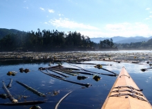
As a sea kayaking enthusiast who enjoys paddling the waters of Washington’s Puget Sound, I need to have up-to-date information about the currents I’m passing through. Accurate predictions of the strong tidal currents in the sound are critical to safe navigation, and kayak trips in particular need to be timed carefully to ensure safe passage of certain regions.

As a NOAA oceanographer and modeler, I also depend on accurate information about ocean currents to predict where spilled pollutants may travel in the marine environment.