
In our changing world, new and more intense forms of marine pollution threaten coastal ecosystems, economies, and communities.
To combat these emerging challenges, scientists from NOAA’s Office of Response and Restoration (OR&R) collaborate with leading experts on topics like marine debris, environmental economics, endangered species, environmental chemistry, and many other subjects that intersect with pollution science.
These studies have different goals, but all advance OR&R’s ability to respond to, assess the impacts of, and restore the environment after oil spills, chemical accidents, hazardous waste, and marine debris pollution.
This blog highlights some recently published scientific advances supporting pollution response and assessment.
Oil Spill Research Applications
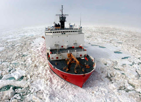
Further Advances in Detecting Arctic Oil Spills
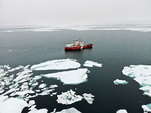
Scientists from OR&R partnered with the U.S. and Canadian Coast Guards, the Coastal Response Research Center (a partnership between OR&R and the University of New Hampshire), the Oil Spill Recovery Institute, Sandia Labs, and remote sensing consultants at Water Mapping, LLC to advance OR&R’s capacity to respond to and assess impacts from oil spills in the Arctic.
The team was on board the Canadian Coast Guard ice breaking vessel Sir Wilfrid Laurier north of the Arctic Circle, and used an uncrewed aircraft system (UAS) platform to collect data used to make surface ice maps. This work complemented earlier shore-based controlled tests conducted on the North Slope of Alaska at Oliktok Point with “totes” of oil, water, and ice.
Ultimately, these projects will develop algorithms that relate temperature and reflectance of oil, water, ice, and other environmental features (e.g., tundra, snow, wildlife) to support rapid work flows for production of mapping products that can support response and assessments during and following oil spills in ice environments.
NOAA and Partners Release New Report on Estimating and Measuring Oil Slick Thickness

NOAA and partners recently released a new report on oil slick thickness, Comparing Recent Advances in Estimating and Measuring Oil Slick Thickness: An MPRI Technical Report.
The OR&R project, funded through the Canadian Multi Partner Research Initiative, involved several years of collaboration, including conducting a workshop with multiple oil spill response and assessment stakeholders, followed by testing with eight different scientists who can estimate and/or measure oil slick thickness.
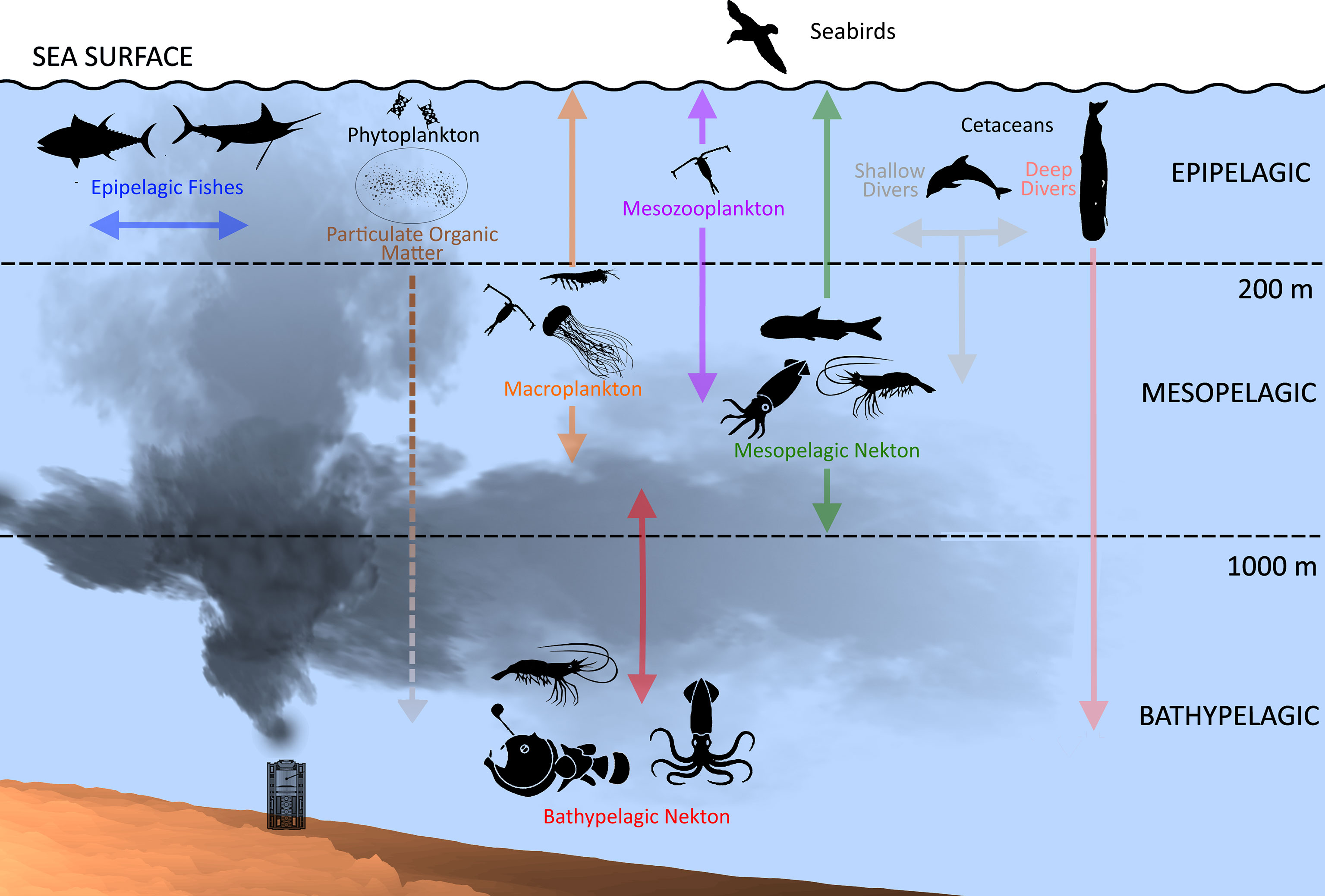
Understanding oil slick thickness is important for spill response and assessment. Responders need to know where the heavy oil is to guide deployment of limited response assets, or the size of the total oil "footprint” on the water. Responders need to know how surface oil of different thicknesses mix into the shallow surface mixing layer for fate and transport modeling, for understanding how sensitive resources (such as early life stages of fish and plankton that are just beneath the slick) are affected by the oil mixed into the water.
The Coastal Response Research Center worked with NOAA and partners (the Bureau of Safety and Environmental Enforcement, the U.S. Coast Guard, the Environmental Protection Agency, and the Alaska Oil Spill Recovery Institute) to develop lab test protocols that can be used to determine which sensors and samplers work best under various oil slick conditions.
Controlled tests were conducted at the University of New Hampshire’s high bay oil testing facility and at the Bureau of Safety and Environmental Enforcement’s National Oil Spill Response Research & Renewable Energy Test Facility, with different operators of sensors and samplers. The final report describes the testing protocols that were developed and the findings of the experiments.
Examining the Effects of the Deepwater Horizon Oil Spill on Coastal Marshes
OR&R scientists were among those conducting a new study that examined the effects of the 2010 Deepwater Horizon oil spill on shoreline erosion of coastal marshes as well as the influences of planting following oiled marsh cleanup.
The authors confirmed that marsh erosion at their field sites substantially increased for two years in heavily oiled marshes after the spill. They attribute this primarily to impacts on the vegetation and reduced soil shear strength attributed to the spill, rather than the separate influences of hurricanes or wave exposure variation.
These findings have reinforced other studies from this heavily examined spill, and crucially show that marsh planting during a response can greatly reduce oiled marsh erosion. The positive influences of planting can extend beyond the immediate impact period of the spill and should be a focus for future responders.
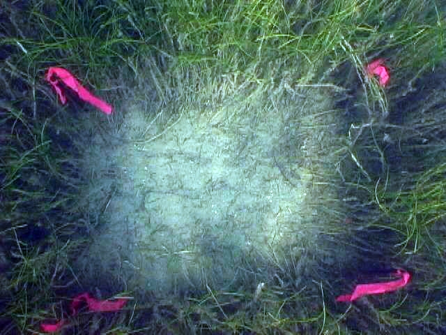
Research on Impacts of Oil on Sand Beaches
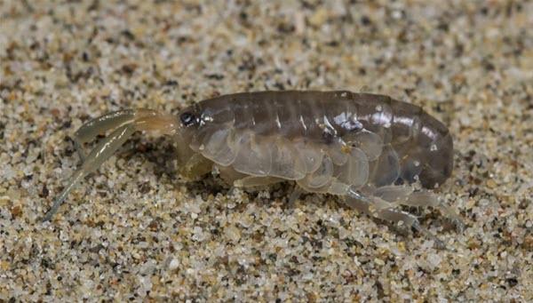
OR&R scientists and partners recently published a paper on PAH (polycyclic aromatic hydrocarbons) uptake by talitrid amphipods (beach hoppers) via habitat (sand) and food (kelp) exposure.
The paper documents work conducted as part of an oil spill in California and demonstrates that the predominant pathway for exposure of these amphipods to oil is through contaminated beach sediment.
Talitrid amphipods live in the intertidal zone of beaches and are primary consumers of plant materials (wrack) that wash up on shore and are prey for birds and fish. These organisms are important to the beach food web and can be exposed to hydrocarbons by direct contact with oiled sand through burrowing and by the consumption of oiled wrack.
This important work indicates that talitrid exposure to PAHs from oil spills is driven by exposure to beach sediment and much less so by consumption of wrack. It highlights a key pathway for how negative impacts can occur to sandy beach ecosystems from oil spills.
Pollution Impact on Marine Mammals
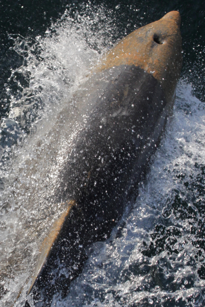
Evaluating How Dolphins Are Impacted By Oil Spills
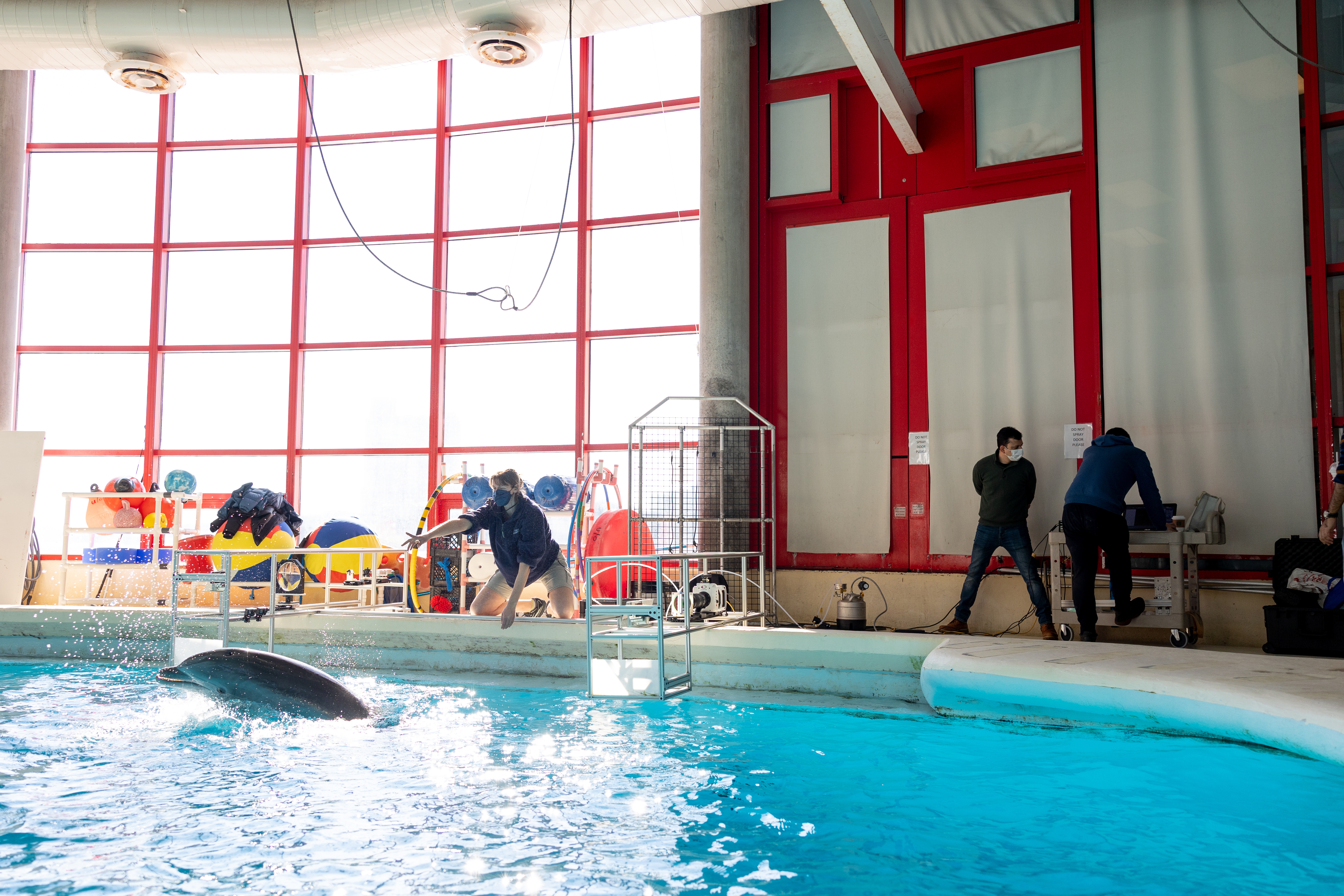
Dolphins may be known for their speed and agility in the water, but even these marine acrobats cannot avoid the negative impacts of oil spills. OR&R scientists are working with the dolphins and caretakers at the National Aquarium in Baltimore, Maryland to study dolphin behavior and better understand the impacts of oil spills on dolphins.
To effectively plan for response and restoration, and to identify ways to mitigate threats, scientists need a better understanding of how cetaceans are harmed by surface oils and dispersants. This study analyzed how particular thicknesses or qualities of oil pose different risks to marine mammals, and if there is a window of time after a spill where response activities are optimally beneficial.
In 2022, scientists examined the dynamics of a dolphin’s breath at the surface to better understand how much floating material may make it into the animals’ lungs. To collect this information, scientists took high-speed videos of dolphins doing what comes naturally to all mammals: breathing air. The video captured various types of inhalations and exhalations, and the droplets they created.
See this summary of how NOAA and partners assess the health of dolphins after pollution events.
Workshop Report on Data Gaps and Oil Spill Impacts on Dolphins
NOAA’s Office of Response and Restoration and the Coastal Response Research Center co-sponsored a virtual workshop in 2022 focused on identifying bottlenose dolphin data gaps in the Greater Houston area.
The workshop addressed data needs, distribution, health, and challenges of these dolphin stocks and how this information could support potential future natural resource damage assessments in the region.
The two-day workshop included federal, state, and local partners presenting on and discussing existing data and ongoing threats to the animals. The workshop report, including presentation summaries, is available online.
New Publication on Discounting in Natural Resource Damage Assessment

OR&R economists co-authored a paper, Discounting in Natural Resource Damage Assessment.
The paper provides natural resource damage assessment (NRDA) practitioners with alternatives, justifications, and implications of choices of the discount rate, used to balance costs of injuries and benefits of restoration across time. The discount rate allows one to translate past and future outcomes into common, present values.
In recent years the responsible party community has been advocating for a lower discount rate. NRDA cases often involve long-term injuries or restoration that occur over many years in the past and future. The choice of the discount rate can have a significant impact on the magnitude of injury costs and restoration benefits (i.e., costs and benefits compound over long periods).
Historically, the discount rate in NRDA was simply based on data observed from financial markets. In recent decades, that same underlying data could be used to support a different result—a lower discount rate. This has prompted damage assessment practitioners to reevaluate the original framework supporting a 3% discount rate.
The new publication reviews the original framework alongside a new one based on the “coerced loan theory.” It argues that both are useful for understanding the damage assessment discount rate. The original framework, applied to new data, produces a lower discount rate, while the new framework produces a higher one. The publication provides justification for continuing to use 3%, and suggests customized alternatives if parties cannot agree on the 3% rate.
Marine Debris Research
Evaluating the Benefits of Marine Debris Removal
Through a joint project between the Marine Debris Program and Assessment and Restoration Division, former OR&R staff conceptualized and published an article, Ecosystem-Service Scaling Techniques to Evaluate the Benefits of Marine Debris Removal, that establishes a new framework to calculate the benefits of removing marine debris from the environment.
Different types of ecosystems, like seagrass and beaches, are impacted by marine debris differently and respond to marine debris removal in different ways. This research developed a framework for analyzing the negative impacts of marine debris, along with methods to quantify the benefits of marine debris removal under different scenarios. This work helps resource managers to evaluate where, and what type, of marine debris restoration projects they should pursue.
Reviewing Shoreline Debris Data for Monitoring in the North Pacific
A publication by a group of scientists, and led by the Marine Debris Program Chief Scientist, reviewed published data on shoreline debris abundances across the North Pacific Ocean and made recommendations for harmonizing monitoring efforts in the region.
The article, Towards a North Pacific long-term monitoring program for ocean plastic pollution: A systematic review and recommendations for shorelines, examined data and methods from 81 papers documenting shoreline debris and found that most studies were less than a year in length and most sites were only visited once. The article proposes a series of guidelines for marine debris shoreline sampling metrics, indicators, methods, and target goals to improve comparability and repeatability of future studies.
The article was written in response to the Terms of Reference for Working Group 42 of the North Pacific Marine Science Organization (PICES). The group is evaluating indicators of marine plastic pollution through the drafting of four companion review papers examining the abundance and distribution of plastic pollution in biota, water, sediments, and on shorelines.
Enhancing Marine Debris Detection with Uncrewed Aircraft Systems
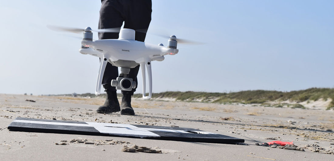
Through a cross-NOAA effort, the Marine Debris Program and National Centers for Coastal Ocean Science supported research in collaboration with Oregon State University and ORBTL AI to investigate three marine debris detection systems that enhance existing shoreline detection methods. Current methods to categorize shoreline debris involve walking to identify and record debris. Through this project, the research team investigated and codified a process to enhance these existing detection efforts using uncrewed aerial systems (UAS), machine learning, and polarimetric imaging cameras.
Polarimetric images were shown to improve the classification of marine debris on shorelines compared to standard red-blue-green images, as this technology can better capture information about surface texture, material type, and shape.
The project team conducted experiments at three different locations in Oregon and Texas and developed operational guidelines on how to best conduct surveys using an UAS integrated with a polarimetric camera. Additionally, the team launched a free, open-source machine learning model called DebrisScan. This technology allows users to upload and process their own aerial images to generate labeled photos and information about potential debris, including the material type, distribution, and quantity.
The tools and guidelines developed as part of this project not only enhance existing shoreline debris detection efforts, but provide reliable and efficient detection, identification, and geolocation of marine debris.
Authoring/Co-Authoring of Studies
Report Reviews Oil in Ocean Environments
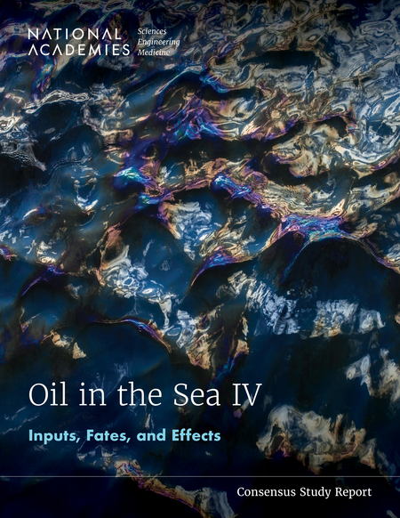
OR&R scientists contributed to the report, Oil in the Sea IV: Inputs, Fate and Effects, released in late December, 2022 by the National Academies of Sciences, Engineering, and Medicine (NASEM).
The report, which updates the previous “Oil in the Sea III,” is the result of a two-year review conducted by a committee of scientists within the oil science field. In May 2023, the Oil in the Sea IV publication was voted by the Ocean Science Board as one of the ten most significant NASEM reports in the past decade.
After reviewing recent literature and consulting numerous national and international professionals, the committee estimated land-based and open ocean oil and fuel inputs, provided updates on oil and hydrocarbon chemistry, and presented new information on the effects of oil and fuel spills, as well as spill response methods, on ecosystems and human health.
Synthesizing Research on the Open Ocean of the Gulf of Mexico
An OR&R scientist contributed to the publication of a paper, The Open-Ocean Gulf of Mexico After Deepwater Horizon: Synthesis of a Decade of Research, in May of 2022 that synthesized a decade of research on the open ocean of the Gulf of Mexico following the Deepwater Horizon oil spill in 2010.
The open-ocean ecotype comprises ~90% of the volume of the Gulf of Mexico, and this research examined key elements of the open-ocean ecosystem, with emphasis on vulnerability and resilience. They found that population declines of many open-ocean taxa appear to be ongoing a decade later and concluded that this largest of Gulf ecosystem components, like its deep-benthic counterpart, remains extremely fragile.
Preparing for Arctic Oil Spills
Oil Spills in the Arctic is a chapter in the book “Arctic One Health, Challenges for Northern Animals and People” that reviews the current science on oil spills to support holistic decision-making for Arctic environments and communities.
Rapidly warming temperatures in the Arctic are opening new shipping pathways and increasing the risk of oil spills. This chapter examines how oil spills impact Arctic environments, wildlife, and people. It also analyzes regional spill prevention and response capabilities and identifies future risks.
An OR&R scientist co-wrote the chapter, which includes references to NOAA work, personal experiences of responders, and graphics that bolster our understanding of how oil spills impact unique Arctic environments.