A plastic drift card released on December 27, 1976 near Nantucket, Massachusetts was found 3,000 miles away and 48 years later on the Isle of Coll in the Inner Hebrides of Scotland.
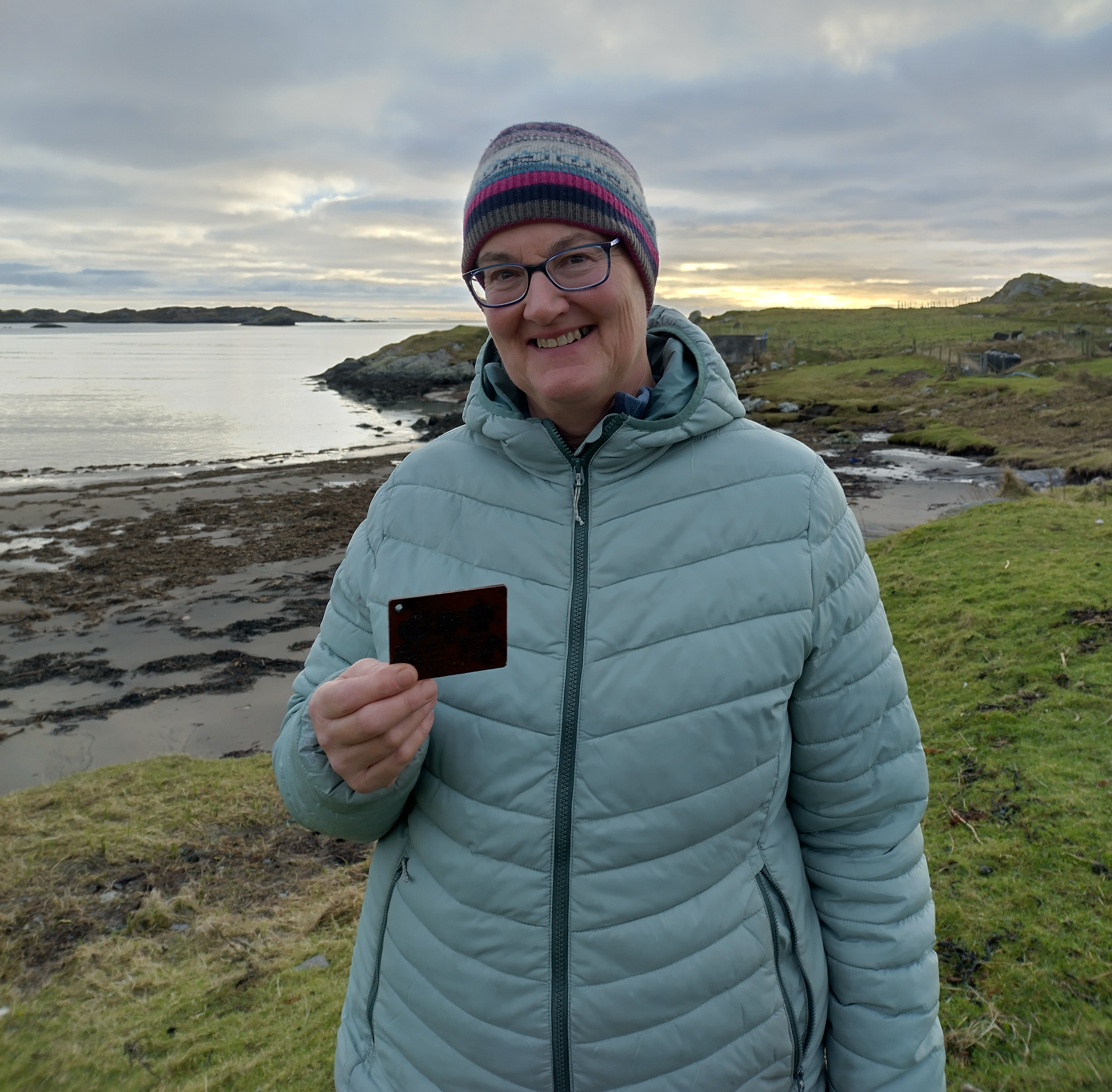
Barbara Payne, a longtime resident of the Isle of Coll off the coast of Scotland, was cleaning up after a storm on October 22, 2024. The storm tossed seaweed and other debris on the track to her house. While cleaning up the road, she was careful to sort through and remove any plastic debris. As an avid beachcomber, Barbara noticed among the debris a red, credit-card size piece of plastic that had some writing on it. Closer inspection showed that it had instructions in English, French, and Spanish to report the find to “NOAA” in Boulder, Colorado. Barbara did a quick online search and found NOAA’s Office of Response and Restoration (OR&R) blog posts about similar drift cards found in France and Portugal and Cornwall (Argo Merchant photo collection).
So what was the purpose of the card? That is a long story that weaves in the history of oil pollution and NOAA, the energy crisis of the 1970s, the environmental movement, the Trans-Alaska Pipeline System, and a lost oil tanker on a dark, stormy night off the coast of New England.
The short story is: The card, and thousands like it, were intentionally distributed into the ocean as a tool to help track oil pollution from the stricken tanker Argo Merchant. Drift cards are often released as a part of an oil spill response to gather information about the direction of the currents in an area, and hence, the possible drift of an oil spill. Historically, drift cards were made of plastic. Drift cards used today are made of bio-degradable wood, coated with bright, non-toxic paint to reduce harm to the environment.


The long story starts with the 1973 oil embargo that plunged the U.S. into a serious energy crisis. Oil became a national security issue, especially in Alaska. On November 16, 1973, President Richard Nixon signed the Trans-Alaska Pipeline Authorization Act, leading to concerns about spills in Alaska. This federal law authorized the development and delivery of oil and gas from Alaska’s North Slope to Port Valdez. Energy security efforts didn’t end there. Offshore oil leasing and exploration was planned around the country and growing environmental concerns led to the development of the Outer Continental Shelf Environmental Assessment Program (OCSEAP).
In support of OCSEAP, NOAA established the Spilled Oil Research (SOR) Team to study the effects of oil and gas exploration in Alaska, and develop better models to forecast the movement of spilled oil. This team was a network of coastal geologists, marine biologists, chemists, and oceanographers that could go on-scene at major spills with the goal of investigating oil spill impacts. One of the research topics was oil fate and behavior. That team, which evolved into OR&R and is now based in Seattle, was initially based in Boulder, Colorado. That is why Barbara’s card directed her to report the card there.
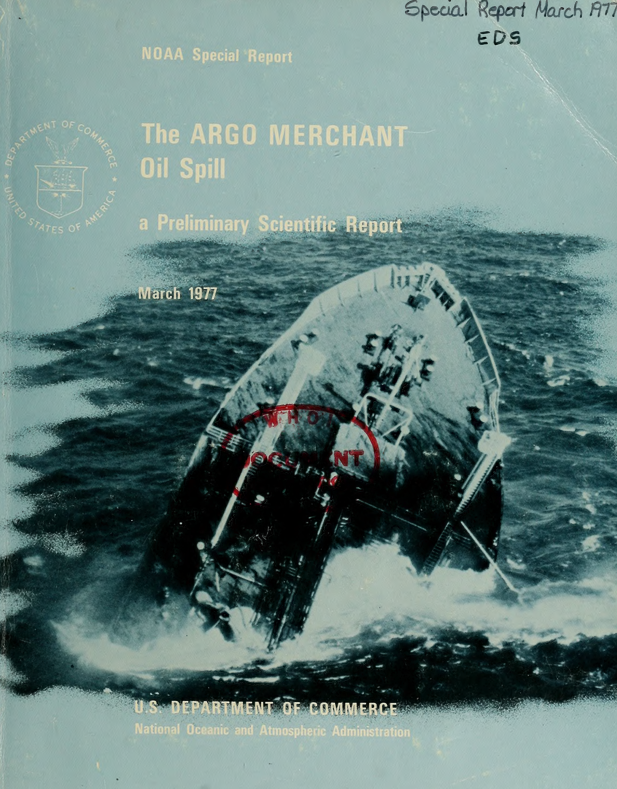
On December 15, 1976, the 640-foot tanker ran aground on a sandbar off the coast of Nantucket Island, Massachusetts when the Trans-Alaska Pipeline was just months from completion. The old ship was lost—more than 24 miles off course—with broken instruments and the crew waiting for sunrise to get a navigational fix. At about 6 am, as the officers struggled to find their position, the ship ran aground. Like every other tank vessel of the time, the Argo Merchant was a single-hull design.
Six days later, after heroic attempts to save the vessel and remove the oil, the vessel succumbed to the high winds and heavy seas of the North Atlantic in winter and broke apart, spilling more than 7.5 million gallons of oil. It was the largest tanker spill in U.S. history at the time, exceeded only by the Exxon Valdez in Alaska 13 years later. The incident is still one of the largest oil spills in U.S. history, and one of the first spills where NOAA had a scientific response role. But not the last. Lessons learned from the Argo Merchant and other spills over the past 48 years have improved NOAA’s ability to respond and restore the impacts of oil spills.
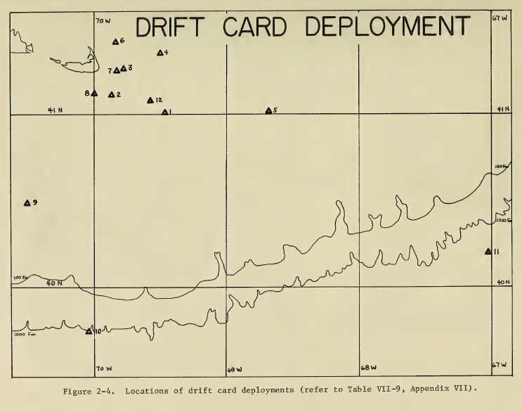
One of the scientific studies conducted on this spill was to predict where the oil might spread and behave in the turbulent and frigid waters of the North Atlantic, and to compare existing oceanographic models to see which ones performed the best. Understanding the oil movement and behavior would improve the response efforts and help understand what natural resources, such as birds and fisheries, might be at risk from this spill. This was the reason for the drift cards. They were designed to be just barely buoyant and travel like floating oil. Studies like this conducted over the years have informed the development of modern oil spill models, such as NOAA’s GNOME suite of spill modeling tools.
It was fortunate that the northwesterly winds prevailing at the time spared coastal areas, fisheries, and beaches by blowing the oil offshore. Because of the direction in which the wind blew the oil, concern about damage focused on economically important fishing grounds in the area of Georges Bank.
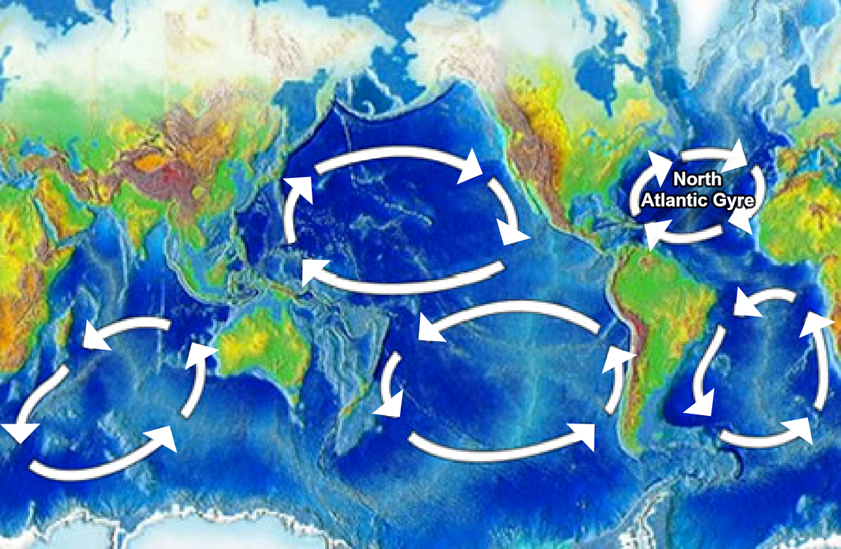
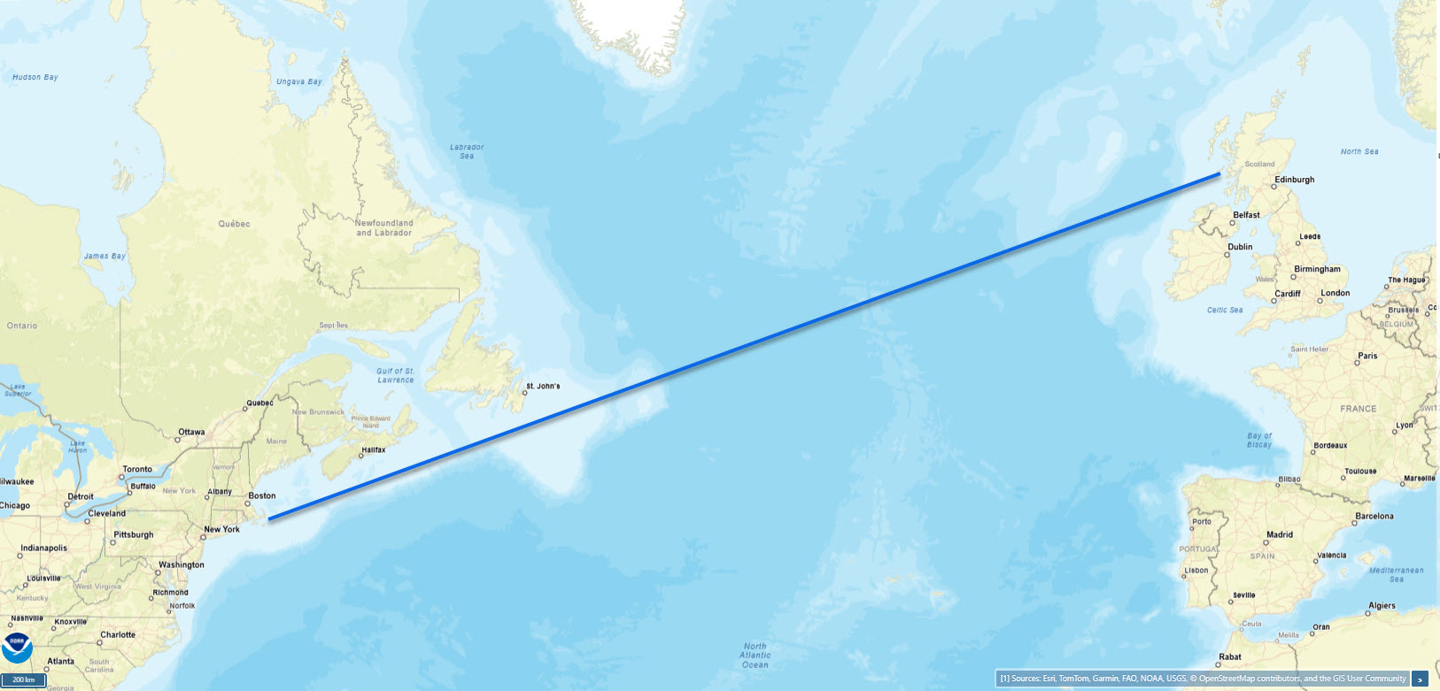
So how did the card get to Scotland? The Gulf Stream follows the eastern coastline of the United States and Newfoundland. It is part of the North Atlantic Gyre, a clockwise-rotating system of currents also called an “ocean conveyor belt.” The gyre carries warm water from the tropics up to the North Atlantic, moderating the temperatures there, but also carrying floating objects. The drift card followed the currents of the North Atlantic Gyre that ultimately led it to the shoreline of Scotland.
Why was the drift card still in the ocean? We don’t know the path that Barbara’s card took. It may have gone around the gyre multiple times, but may also have been tossed up on shore during a storm and sat there for decades until liberated by another storm. It is difficult to understand how long a material will last once it enters the ocean because materials break down in different ways, especially plastic. After 48 years, the drift card that Barbara found is evidence that plastics can last for decades in the environment, and may never fully go away. We don’t use plastic drift cards anymore to study ocean currents since technology has since evolved, but the drift card demonstrates the persistence of plastic in the ocean.