
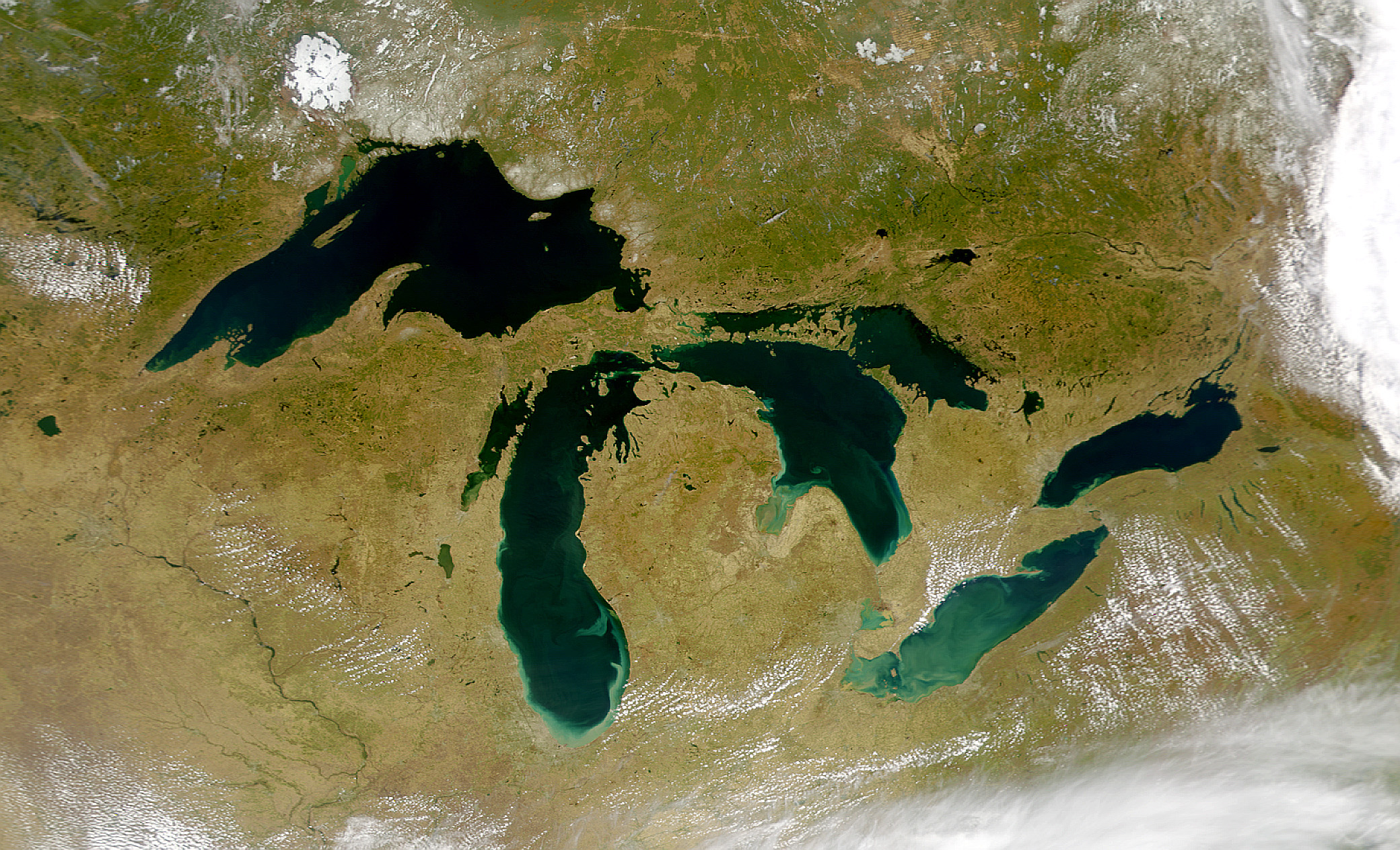
The Great Lakes region stands as a crucial ecosystem, supporting diverse species, habitats, and communities integral to both environmental health and human livelihoods. Despite its significance, this area has historically lacked robust scientific data, leaving sensitive ecosystems and underrepresented communities vulnerable to various threats such as pollution and invasive species.
In recent years, there has been an increase in efforts to protect the Great Lakes, driven by significant events that highlighted the pressing need for action. For example, the 2010 oil spill in Talmadge Creek and the subsequent contamination of the Kalamazoo River, resulting from a rupture in the Enbridge pipeline, were pivotal moments. These incidents prompted the Office of Response and Restoration (OR&R) to assess environmental damage and establish restoration objectives as part of the Natural Resource Damage Assessment Process (NRDA).
A National Partnership is Formed
OR&R supports the protection and restoration of natural resources of the Great Lakes from oil, chemical, marine debris, and disasters. As part of our mission, OR&R has supported research and development on oil spills in the Great Lakes, working with our close partner and collaborator, the U.S. Coast Guard (USCG) Great Lakes Oil Spill Center of Expertise (GLCOE). In 2018, a provision was signed into law to establish the GLCOE to serve as a central hub for advancing research and response capabilities across the region. The center was established to build on the work already happening to further advance research, development, and testing of freshwater oil spill response efforts.
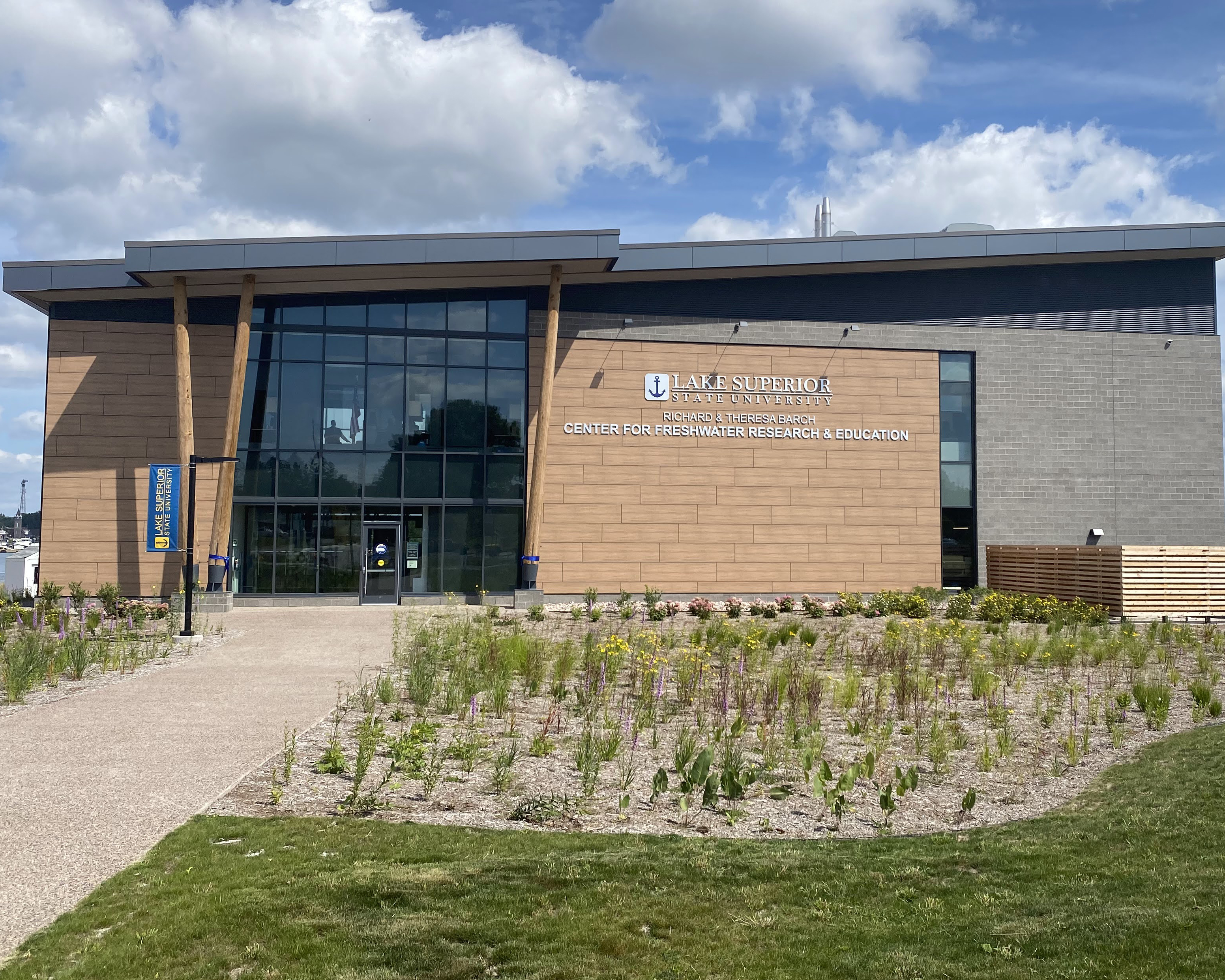 Through our GLCOE partnerships, we have increased collaborations and connections with two Great Lakes research centers serving as the dual office location for the GLCOE, the Center for Freshwater Research and Education (CFRE) at Lake Superior State University in Sault Ste. Marie, Michigan and the NOAA Great Lakes Environmental Research Laboratory (GLERL) in Ann Arbor. Together, the efforts are advancing knowledge for Great Lakes spill preparedness and response
Science to Understand Oil-In-Ice Environments
OR&R has conducted many GLCOE-funded research projects, including the first experiment ever conducted with GLCOE funding at Lake Superior State University which focused on ice and oil-in-ice. In the spring of 2023, OR&R aimed to advance science and operational capabilities for freshwater spill responses and assessments.
Scientists from OR&R, the USCG, the Coastal Response Research Center (CRRC), and partners developed and tested operational capabilities for using uncrewed aerial systems (UAS), commonly referred to as “drones”, with various sensors to characterize oil-on-water and oil-in-ice environments in the Great Lakes. In order to characterize ice and oil-in-ice without introducing oil into the environment, the teams conducted shore-based controlled testing with oil and ice in totes in daylight and darkness at the GLCOE facility along the icy shores of the St. Mary’s River.

The teams also conducted UAS testing from aboard the USCG Cutter SPAR while breaking ice in Duluth Harbor. Field trials aimed to operationalize the use of UAS with USCG pilots, using USCG-owned equipment operating in the Great Lakes in cold and ice environments. Experiments and testing advanced understanding of oil and diesel slick detection, characterization, and capabilities for operating in cold weather and in ice-infested waters of the Great Lakes.
Using Remote Sensing to Detect Oil Slicks
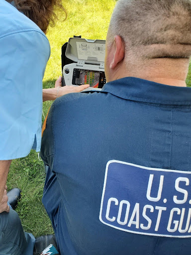
At the CRRC, the GLCOE is funding a project utilizing UAS remote sensing to test capabilities for detecting oil slicks on water. Drones carrying different sensors can be flown over oil spills to help direct response and assessment efforts. Teams are testing several sensors that could be deployed in the Great Lakes, including hyperspectral, thermal infrared, polarimetric, and optical.
In recent testing, USCG UAS pilots flew over an array of experimental tanks with differing amounts and types of oil (crude oil, very low sulfur fuel oil, marine diesel, and dielectric fluid) to determine which UAS sensors were best able to “see” the different oil types, better understand what their detection limits were (how thin of a sheen was visible in the imagery collected), and test and develop protocols for rapidly transferring the data collected from UAS flights into the Environmental Response and Management Application (ERMA®).
This project, and others previously completed and currently underway, are a testament to the strong collaboration and partnership that advances oil spill response and assessment across OR&R and the spill response community. While the focus of the GLCOE is to protect and conserve the Great Lakes region, increased understanding of oil in the environment and utilization of new technologies serves every region.


Tools to Map Spill Trajectories
OR&R also has national oil spill response projects working with the GLCOE including one to develop a Trajectory Analysis Planner (TAP) analysis which will aid response agencies with contingency planning in the Great Lakes region. To prepare for possible oil spills from likely sources, OR&R developed TAP which uses thousands of runs of the GNOME trajectory model, forced with varying winds and currents in order to develop a statistical view of where oil is likely to go in the event of a spill. This allows for improvements in planning and preparedness for prevention of harm from oil spills. TAP is now available as a web application, WebTAP, making it much more flexible and easier for planners and responders to access.
Data to Understand Impacts from Oil Spills
In addition to supporting oil in the environment research, there was a need to focus on updates to Environmental Sensitivity Index (ESI) maps and data in the Great Lakes. These products are the leading sensitivity tool for oil and chemical spill responders, used in a wide range of other cases across the public and private sectors such as planning, permitting, and resource assessment. This work called upon the established partnership between NOAA and the USCG to advance protection and response efforts in the Great Lakes. As part of this partnership, the GLCOE funded updates to the ESI datasets for the St. Marys and St. Lawrence Rivers (2021) and for Lake Erie (2022), which were the first updates to these datasets since they were created in the mid-1980s.
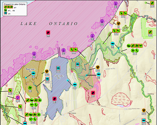
The ESI datasets for the Great Lakes region include shorelines in eight states: Minnesota, Wisconsin, Michigan, Illinois, Indiana, Ohio, Pennsylvania, and New York. OR&R welcomes coordination and partnerships, like that with the USCG GLCOE, to help support ongoing ESI update efforts. This partnership, as well as our partnership with the Great Lakes Restoration Initiative (GLRI), is enabling updates to ESI datasets for the entirety of the Great Lakes, including critical high-risk marine transportation corridors.
ESI funding enabled a refresh of the Lake Ontario dataset which was completed in the fall of 2023, and an update to Lake Michigan’s contract is currently underway with an anticipated release of 2025. Updated datasets for Lake Huron and Lake Superior are anticipated in 2026. The updated data provides a major boost to spill planning and preparedness activities in the Great Lakes and has brought the region’s ESI data into the digital realm for the first time.
Advancing Science and Data to Protect Great Lakes Resources
NOAA and our partners remain concerned about threats to the Great Lakes and strive to build research and response capabilities. There are many facets of OR&R working towards resiliency in the Great Lakes region including the NOAA Marine Debris Program and the Assessment and Restoration Division. To date, OR&R and partners have recovered over $33.19M in Michigan from polluters for restoration of injured natural resources.
Also, as part of OR&R’s all-hazards mission, and in partnership with the CRRC, OR&R’s Disaster Preparedness Program facilitated a workshop on harmful algal blooms in the Great Lakes to dive into the preparedness and response capabilities and responsibilities across the federal government and state agencies. Even when project funding ends, the collaboration doesn’t stop. The CRRC has taken the lead in forming working groups that stem from research projects within our Great Lakes activities. These groups aim to model the fate and transport of oil, chemicals, and other substances in the future. OR&R leverages NOAA-wide resources to enhance preparedness, planning, and response capabilities for natural and human-caused disasters along our coasts.