
Every month, NOAA’s Office of Response and Restoration’s (OR&R) Emergency Response Division provides scientific expertise and services to the U.S. Coast Guard (USCG), ranging from producing oil spill trajectories that estimate where a spill may spread; to identifying possible effects on wildlife and fisheries; to estimating how long oil may stay in the environment. We also receive requests to track and model other floating objects, such as log booms or shipping containers that have broken free, whale carcasses, fish die-offs, and algal blooms.
During February, OR&R provided response support for 26 incidents, including 15 new incidents in ten different states, Puerto Rico, and an international incident in the Red Sea. The 15 new incidents included nine actual or potential oil spills, one chemical incident, five “other” incidents—one mystery drum, one lost container incident, one search and rescue, and two incidents involving dead whales.
OR&R staff prepared 135 incident reports and documents, including 12 fate and trajectory analyses. Cumulatively, these incidents posed an approximate risk of more than 407,876 gallons of oil, 20,000 metric tons of chemicals, 10 derailed freight cars, and 24 lost shipping containers.
(Note: All spill volumes are approximate and based on initial information that may be updated after further investigation.)
Diesel Discharge in Kwigillingok, Alaska


On February 9, the USCG contacted the NOAA scientific support coordinator (SSC) for Alaska, regarding a spill of diesel from a bulk fuel site in the southwest Alaska community of Kwigillingok.
Preliminary reports showed that 2,000 gallons of diesel had been discharged into secondary containment, but that figure was adjusted to 9,000 gallons over time. The release occurred during a fuel transfer from a larger storage tank to a smaller one. Responders were actively recovering free liquids and deployed absorbent booms and pads to stop the spill's spread.
The area impacted by the diesel included snow and ice-covered tundra and a pond in the immediate vicinity of the tank farm. The diesel had not spread to the Kwigillingok River, about 150 feet from the tank farm, nor the housing south of the tank farm.
USCG requested NOAA’s assistance in identifying the resources at risk and in initiating emergency Endangered Species Act (ESA) consultation. The Kwigillingok River is a tidal river, with the spill approximately three miles upstream from Kuskokwim Bay. Two ESA-listed threatened waterfowl species (Spectacled and Steller’s Eiders) are not currently in the area, but they are expected to return with the spring migration. Additionally, two threatened seal species are found in Kuskokwim Bay and potentially within the river, although not at this time of year. The Kuskokwim River Delta is a globally recognized Important Bird Area (IBA), and its vegetated intertidal areas support some of the highest nesting densities of shorebirds in the world. Fortunately, most bird species have not yet arrived on their nesting grounds, but impacts to nesting sites from fuel contamination or recovery efforts may affect nesting birds and their eggs in the spring. The spill is also located within the historic boundaries of the Yukon Delta National Wildlife Refuge.
Alaska Department of Fish and Game has documented that residents of Kwigillingok and other communities in the Yukon-Kuskokwim Delta coast conduct subsistence activities in the region throughout the year, including fishing and harvesting of marine mammals.
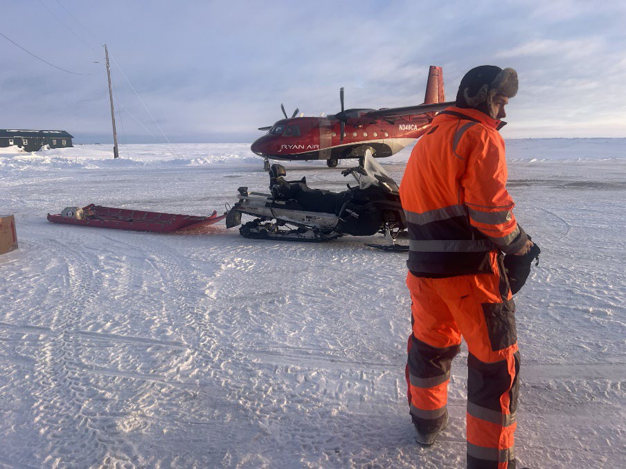
On-scene responders are dealing with challenges often associated with small remote communities: lack of heavy equipment; limited lodging (e.g., commuting daily from Bethel); limited internet and cellular communications; and severe winter weather. In the two weeks post discharge, the area received 24-30” of snow.
The Alaska Department of Environmental Conservation (ADEC), the USCG, and other state and federal agencies will continue to assist with developing response actions for the cleanup, develop tactics to maximize the reuse of recovered diesel fuel, and minimize damage to the environment.
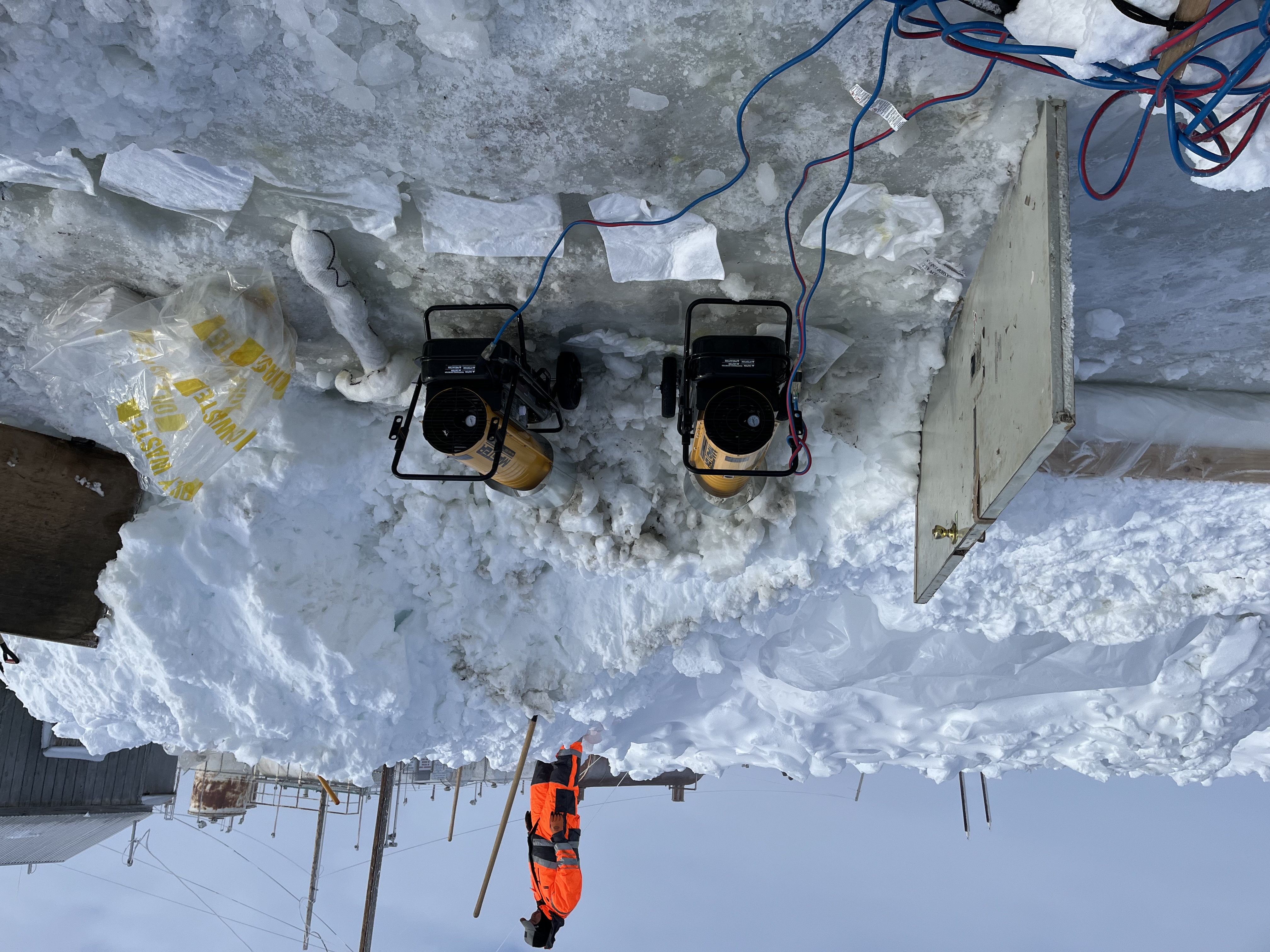
Due to extreme weather conditions, the remote location, and resource-constrained logistics, recovery of the diesel has been limited. Site operations largely focused on delineation of the contaminated area and constructing snow berms and trenches in the snow to contain and collect the diesel when the snow begins to melt in late April through May.
As of March 12, responders have been demobilized. Wildlife agencies are working on a bird deterrent and hazing strategy. Responders will return to the site in spring to continue recovery and containment tactics.
Grounded Fishing Vessel in Bodega Bay, California
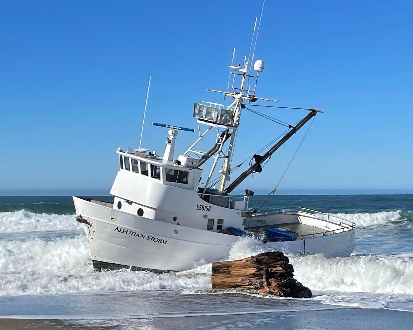
On February 10, the USCG contacted the NOAA SSC for California to report the grounding of a 58-foot fishing vessel, Aleutian Storm, near Salmon Creek, just north of Bodega Bay, California. Grounded on a sandy beach amidst the surf, the vessel did not appear to have sustained any damage, and no sheening or pollution was observed. The vessel had a pollution potential of 3,500 gallons of diesel; however, a lower volume was estimated to be on board. The four persons on board were safely evacuated.
The USCG sought oil fate and transport information from NOAA in the event of a diesel release prior to or during vessel salvage operations. NOAA provided a trajectory indicating that any potential product discharge would remain in the surf zone.
Located on California State Parks property, the grounded vessel was near two environmentally sensitive sites and within the Greater Farallones National Marine Sanctuary. The Coast Guard established a Unified Command that included NOAA, California Department of Fish and Wildlife Office of Spill Prevention and Response (CDFW-OSPR), California State Parks, Sonoma County Sheriff’s Department, and the vessel captain.
The following day, efforts to refloat the vessel at high tide were unsuccessful. When safe working conditions allowed, attempts to remove pollution from the vessel, address the crab catch onboard, and assess the vessel’s integrity continued; however, efforts to refloat or relocate the vessel further up the beach were unsuccessful.
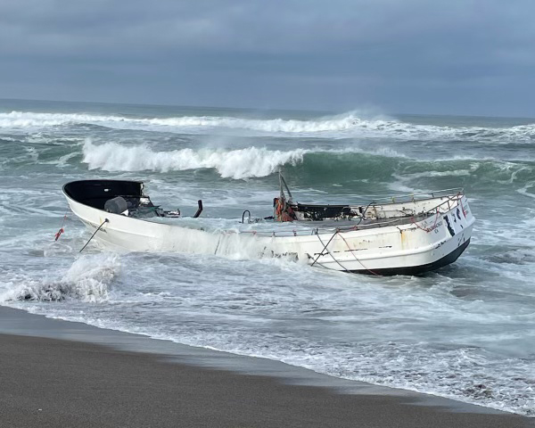
The Unified Command determined that pollution removal operations would be unsafe due to weather conditions and the degraded condition of the vessel and shifted plans to a salvage operation.
On February 19, the USCG and CDFW-OSPR transitioned the authority of lead responding agency to NOAA’s Greater Farallones National Marine Sanctuary, which is leading oversight of the salvage operations in coordination with state and local agencies and the vessel’s owner.
Cargo Vessel Carrying Fertilizer Struck by Missiles in the Red Sea
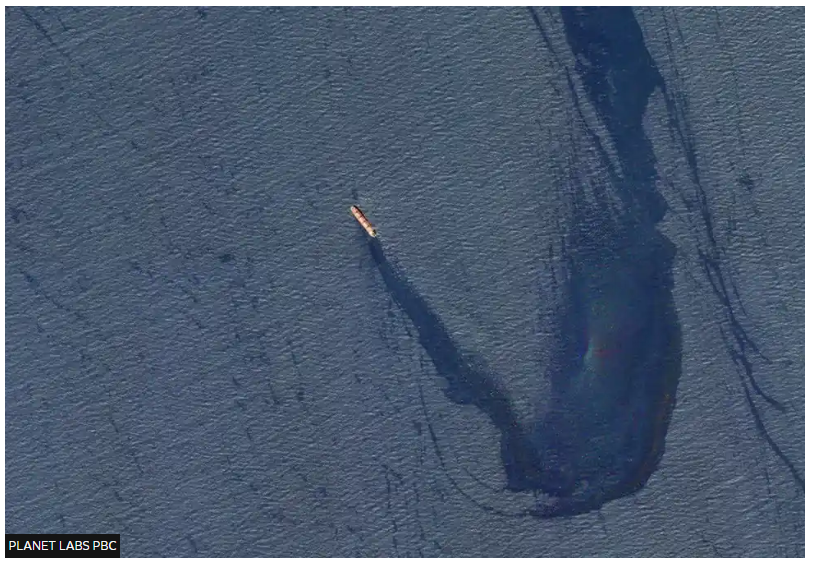
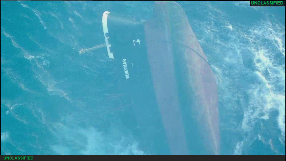
On February 18, the 563-foot Belize-flagged and British-owned bulk carrier M/V Rubymar, loaded with 21,000 metric tons of ammonium phosphate sulfate fertilizer, sustained damage from a Houthi missile strike in the Red Sea. The crew safely abandoned the ship after two missile hits and were rescued by a nearby commercial ship. The strikes occurred near the vessel’s engine room and deck and resulted in an 18-mile oil slick. The vessel’s potential capacity was about 400,000 gallons of fuel oil.
On February 22, the U.S. Navy, through U.S. Central Command (CENTCOM), requested NOAA's expertise and scientific support, specifically in determining the potential effects from an uncontrolled release of the fertilizer. NOAA’s guidance is being provided by oil and chemical spill scientists from OR&R’s Emergency Response Division, supported by scientists from NOAA’s National Centers for Coastal Ocean Science (NCCOS), who are experienced in nutrient cycling, eutrophication in estuaries, and tracking algal blooms via remote sensing.
On March 2, after slowly taking on water and dragging anchor, the Rubymar remained grounded by its stern miles from where it was initially struck, and is expected to ultimately sink.
NOAA OR&R and NCCOS scientists remain available to consider further support requested by CENTCOM.
Shipping Containers Lost offshore of Monterey, California
On February 7, the USCG contacted the NOAA SSC for California to report the loss of 24 shipping containers from the M/V President Eisenhower the prior night, approximately 64 nautical miles southwest of Monterey, California.
No hazardous materials were in any of the lost containers and it was not clear at the time of the report whether any containers were insulated or refrigerated. The USCG ran their SAROPS (Search And Rescue Optimal Planning) model to provide an initial drift estimate, indicating downcoast movement.
On the morning of February 9, a USCG aircraft observed a shipping container to the southeast of the reported drop location, near the southern reaches of the Monterey Bay National Marine Sanctuary. Sanctuary staff contacted the SSC to request further trajectory information on the floating container to better inform sanctuary decisions.
On March 4, a cotton-like substance was observed and photographed within several rocky intertidal areas between Morro Bay and San Simeon Beach, as well as some lumber (possible wine barrel debris). Four shipping containers lost from the M/V President Eisenhower were known to contain 349 bales of raw cotton. A spill response contractor was engaged to conduct overflights, determine debris collection areas, and address debris, as appropriate.
 fate and transport model. Image credit: NOAA.")


Here is the complete list of February’s incidents. Click on the links to find out more:
- Sunken Recreational Vessel; Seekonk River, East Providence, Rhode Island
- Hydraulic Fluid Discharge from Jack-up Rig; Gulf State Park Pier, Gulf Shores, Alabama
- Damaged Freighter Rubymar, Red Sea; Gulf of Aden
- Dead North Atlantic Right Whale; floating off the coast of Georgia
- Abandoned Mystery Drum; Mona Island, Puerto Rico
- Grounded F/V Aleutian Storm; Bodega Bay, California
- Sunken Pleasure Craft; Detroit River, Michigan
- 24 Lost Shipping Containers; offshore of Monterey, California
- Diesel Discharge; Kwigillingok, Alaska
- Heavy Fuel Oil Discharge into Galveston Bay; Texas City, TX
- Crude Oil Spill into Black Lake; Hackberry, Louisiana
- Train Derailment; Pittstown, New York
- Request for Whale Carcass Drift Analysis; North Carolina Coast
- F/V Jacob Pike Sunk in Shallow Water; New Meadows River, Harpswell, Maine
- Overdue Sailboat; Eastern Pacific between Los Angeles and Hawaii