
Every month, NOAA’s Office of Response and Restoration (OR&R)’s Emergency Response Division provides scientific expertise and services to the U.S. Coast Guard (USCG), ranging from producing oil spill trajectories that estimate where a spill may spread; to identifying possible effects on wildlife and fisheries; to estimating how long oil may stay in the environment. We also receive requests to track and model other floating objects, such as log booms or shipping containers that have broken free, whale carcasses, fish die-offs, and algal blooms.
So far this year, OR&R has provided support for 150 incidents. During November 2023, OR&R provided response support for 28 incidents, including 13 new incidents in eight different states. The 13 new incidents were all actual or potential spills, for which OR&R staff prepared 194 incident reports and documents, including eleven fate and trajectory analyses. Cumulatively, these incidents posed an approximate risk of more than 1,229,000 gallons of oil.
(Note: All spill volumes are approximate and based on initial information that may be updated after further investigation.)
Here are some of November's notable incidents:
Crude Oil Release: Main Pass, LA
On the morning of November 16, a release of crude oil in the Gulf of Mexico, off the coast of Plaquemines Parish, Louisiana, was reported to NOAA via the U.S. Coast Guard. The Coast Guard; Main Pass Oil Gathering Company, LLC; and the Louisiana Oil Spill Coordinator's Office established a Unified Command. OR&R oil spill scientists, along with specialists from other NOAA offices, have been supporting the response since that time.
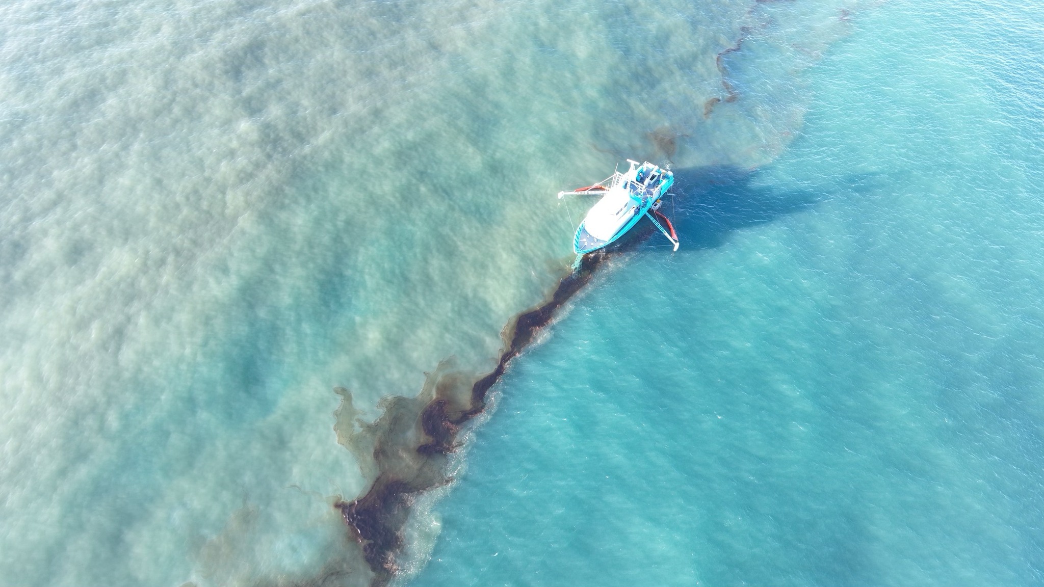
The leak location was thought to be 19 miles offshore of the Mississippi River Delta; however, the exact location, time of the release, and the amount of oil are still being evaluated. The oil has been identified by OR&R chemists as South Louisiana sweet crude oil. The cause and source of the leak remain under investigation.
NOAA is engaged in multiple ways in this incident:
- OR&R provided, and continues to provide, scientific support, including spill trajectory and fate modeling, information on resources at risk, and coordination of NOAA capabilities with the spill response. OR&R obtained and analyzed samples from the pipeline to characterize the oil’s physical and chemical properties, enabling the response team to better predict how the oil will move and its impacts on the environment. NOAA scientific support staff reported to the incident command post on November 16, and will continue to provide technical assistance to the Federal On-scene Coordinator (USCG) and the Unified Command, as requested.
- NOAA Ship Oregon II was conducting a groundfish survey in the surrounding area and played a key role in the initial observation of the slick, and reported observations to OR&R to assist with assessments and trajectory forecasting.
- OR&R has begun the initial phase of a Natural Resource Damage Assessment, with a lead coordinator deploying on-scene on November 18 to gather information and begin coordination of on-scene assessment work. OR&R is also engaged with co-Trustees from the State of Louisiana and U.S. Fish and Wildlife Service, on injury assessment for Natural Resource Damage Assessment.
- NOAA Fisheries is supporting the response effort by engaging with the Unified Command Wildlife Operations Branch to identify and intervene for our trust species (especially marine mammals and sea turtles) in the event that they are identified as oiled; to date, there have not been any oiled mammals or sea turtles observed as part of this release. NOAA Fisheries is also providing best management practices to mitigate the impact of cleanup activities on marine habitats and species, and providing technical support related to endangered and threatened species in the area including the Rice’s whale, giant manta ray, and sea turtles, for both response and Natural Resource Damage Assessment.
- Satellite imagery is being used to identify the possibility of oil presence via Marine Pollution Surveillance Reports, produced by the Satellite Analysis Branch within NOAA’s National Environmental Satellite, Data, and Information Service. The satellite imagery will continue to be made available, as needed.
- NOAA’s National Weather Service forecast office in New Orleans provided forecasts to support the response efforts. The specialists briefed the USCG, National Transportation Safety Board, and the Louisiana Governor’s Office of Homeland Security and Emergency Preparedness on weather conditions, including sea state and winds, and they will continue to provide spot forecasts, as needed.


Sporadic Tar Balls on Northern New Jersey Beaches
On November 28, the NOAA scientific support coordinator (SSC) for the mid-Atlantic region was notified by the Coast Guard and New Jersey Department of Environmental Protection (NJ DEP) of sporadic tar balls on northern New Jersey beaches. Tar balls are small lumps of oil that have weathered to a semi-solid or solid consistency. The reports extended from the municipality of Monmouth Beach south to the municipality of Deal, a distance of approximately eight miles.
In response to these reports, a Unified Command was established by USCG Sectors New York and Delaware Bay, alongside the NJ DEP, U.S. Fish and Wildlife Service, NOAA, and Monmouth County. The Unified Command is responding to the incident and evaluating response and cleanup methods.
The NOAA SSC went on-scene on November 28 to assist with survey and cleanup recommendations. The heaviest concentration of tarballs was located at Seven Presidents Oceanfront Park, a Monmouth County Park in Long Branch, New Jersey. All area beaches surveyed had less than one percent coverage of tar balls, with some areas having no tar balls observed. No subsurface/buried tar balls were found during the November 28 survey.
USCG conducted an overflight covering an area that included lower New York Bay and the coastline, beginning with Sandy Hook, south to Point Pleasant, New Jersey, with no sheen or tarballs being observed in coastal waters. An oil spill response organization was brought on-scene and conducted a trial clean-up demonstration on November 29 to help determine what cleanup method(s) could be effective. The Unified Command finalized a cleanup plan and cleaning work is underway.
At time of publishing this blog, the Unified Command has identified that the pollution originated from a spill that happened during a transfer at an oil facility on the evening of November 22, in Bayonne, New Jersey. The full extent of the incident is still being investigated.
Navy Aircraft in Kaneohe Bay; Oahu, Hawaii
On November 20, the NOAA scientific support coordinator (SSC) for Hawaii was notified that a U.S. Navy P-8A Poseidon aircraft had run off the end of a runway at Marine Corps Base Hawaii into Kaneohe Bay, with 2,000 gallons of Jet-A fuel on board. The plane came to rest in shallow water just offshore. All nine crewmembers were able to make it to shore, and no injuries were reported.
No sheen had been observed at the time of the report. A fate and trajectory analysis was requested from OR&R. Containment boom was deployed, as well as absorbent material to serve as both a preventive measure and to help indicate potential petroleum releases. On November 26, the jet fuel was successfully pumped off the aircraft. Video of an underwater survey of the aircraft is available on the Defense Visual Information Distribution Service’s website.

Several salvage options were considered (e.g., lifting with multiple cranes, float bags, etc.) as part of this response. A number of factors, including weather and environmental concerns, determined the selected method. On December 2, the aircraft was successfully moved out of the bay through a fifteen-plus hour process that used inflatable roller bags to lift the aircraft and its landing gear to roll it to shore. Care was taken to minimize damage to corals, as well as further damage to the aircraft.
A multi-agency group—including the NOAA SSC, environmental staff from Marine Corps Base Hawaii, U.S. Coast Guard, State of Hawaii Hazard Evaluation and Emergency Response Office, and U.S. Fish & Wildlife Service (USFWS)—observed the salvage until the aircraft was clear of the water and on the runway. No fuel or lube oil was released during the removal.
On December 3, a multi-agency dive team conducted an in-water assessment of damage to coral in the area. The team included representatives from NOAA National Marine Fisheries Service Habitat Protection Division, USFWS, Hawaii Department of Land and Natural Resources, and the U.S. Navy. At the time of publishing, the Navy has not yet offered any cause for the mishap, but divers successfully recovered the P-8’s flight data recorder and an investigation is underway.


Here is the complete list of November’s incidents. Click on the links to find out more:
- Sheen and Shoreline Oiling, Gravesend Bay, Brooklyn, NY
- Diesel Discharge Near/Into Glacier Creek at Alyeska Resort, Girdwood, AK
- Sporadic Tar Balls on Northern New Jersey Beaches; Long Branch, NJ
- Little Diomede Building Collapse; Diomede, AK 99762, USA
- Spill of #6 Oil at IMTT Pier; Bayonne, NJ Navy Aircraft in Kaneohe Bay; Oahu, Hawaii
- Tug Releasing Residual Sheen; Orcas Island, WA
- Fishing Vessel Aground; Pleasant Beach, NJ
- Pipeline Release: Main Pass, LA
- Tug and Barge Collide with Pipeline on Columbia River; Clatskanie, OR
- M/V American Courage - St Clair River, Marine City, MI
- Release on Oil Platform, Main Pass Block 35; Buras-Triumph, LA
- Iced-in Barges in Lake Johnson; Nunapitchuk, AK