Oil spill response is an arduous process, involving various stakeholders, trustees, scientists, and responders to minimize harm to the environment, and to ensure damaged natural resources and the public are properly compensated from the losses after an incident. Today, OR&R and the U.S. Coast Guard are working together on developing ways to advance and streamline oil spill response using cutting-edge technologies. In 2023, OR&R kickstarted a project to optimize oil spill response by utilizing uncrewed aircraft systems (UAS), or “drones,” and strengthen data collection and delivery for oil spill response in real-time.
OR&R set up a clear mission to optimize the Coast Guard’s use of UASs to support spill response. For a pilot, the mission is to: perform safe drone takeoff, capture geotagged images and videos that document the surface oiling conditions, perform safe drone landings, upload collected data into OR&R’s data management application Data Integration, Visualization, Exploration, and Reporting (DIVER); and, ideally to create orthomosaic maps to be visualized in OR&R’s online mapping tool, Environmental Response Management Application (ERMAⓇ) within minutes of landing the aircraft. At the end of this procedure, on-the-ground responders would have a better understanding of the oil spill ready at their fingertips to determine how, when, and where to deploy limited response assets in an emergency response.
OR&R and the Coast Guard Team Up to Find the Oil
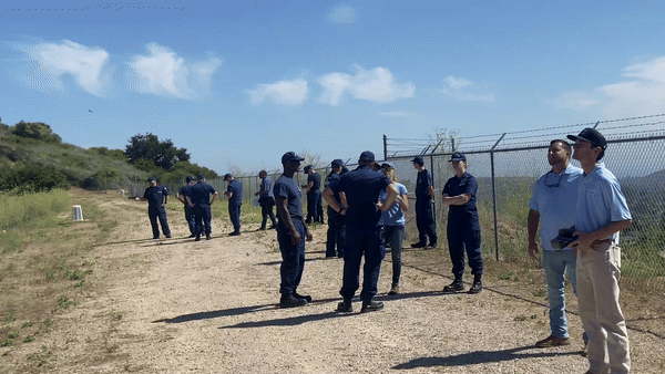
To meet training goals, OR&R, funded by the Coast Guard’s Great Lakes National Center of Expertise and working with the Coastal Response Research Center, held a week-long training in July of 2023, led by Water Mapping, LLC, a remote sensing consulting firm with oil spill expertise.
On day one, a team of 14 USCG pilots and two support pilots from the Couvillion Group met in Santa Barbara, California to undergo ground school to learn two main lessons: (1) how to fly drones to detect and map oil, and (2) how to process oil data and rapidly produce easy-to-read visual products, like maps, that help responders understand oiling conditions in near real time.
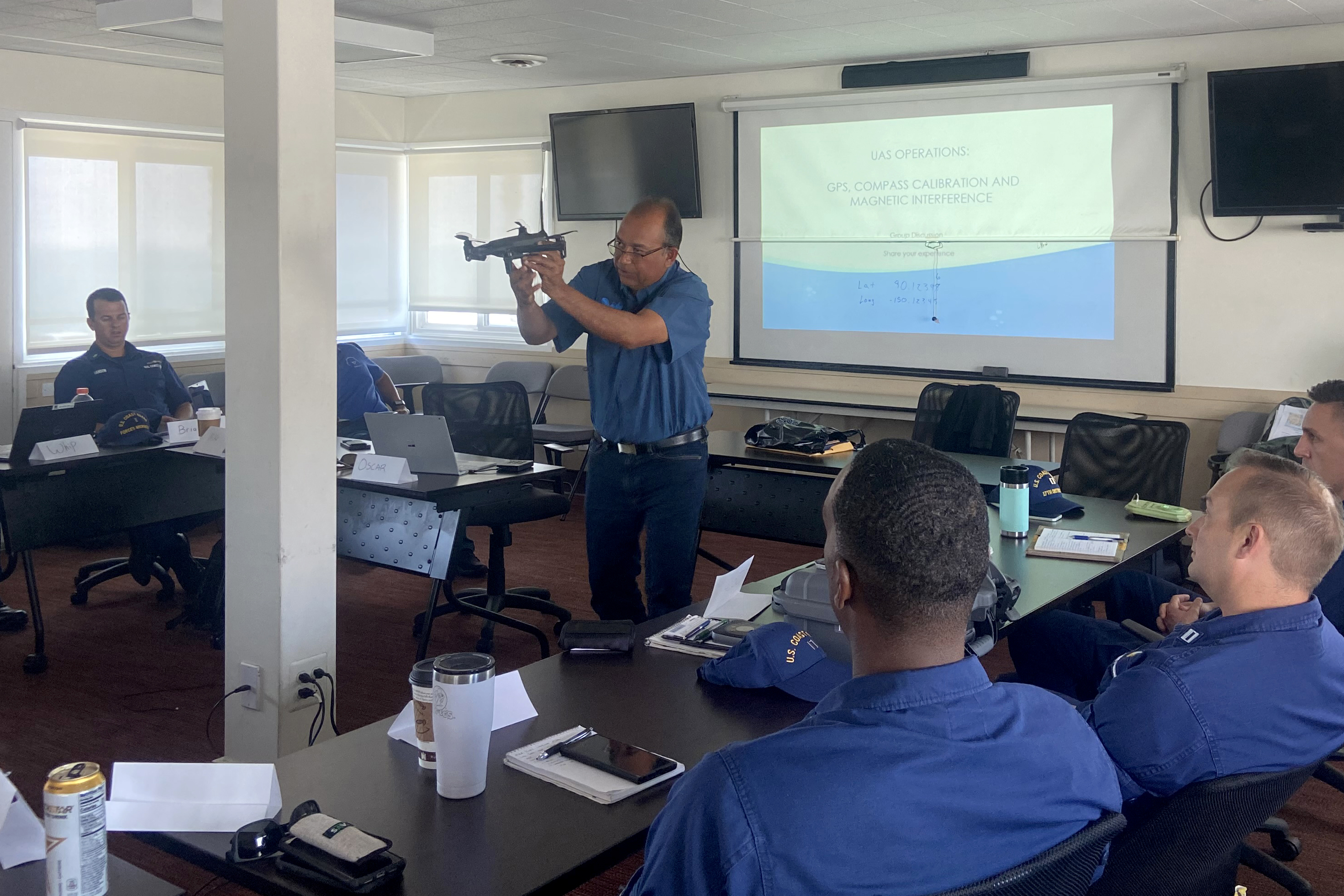
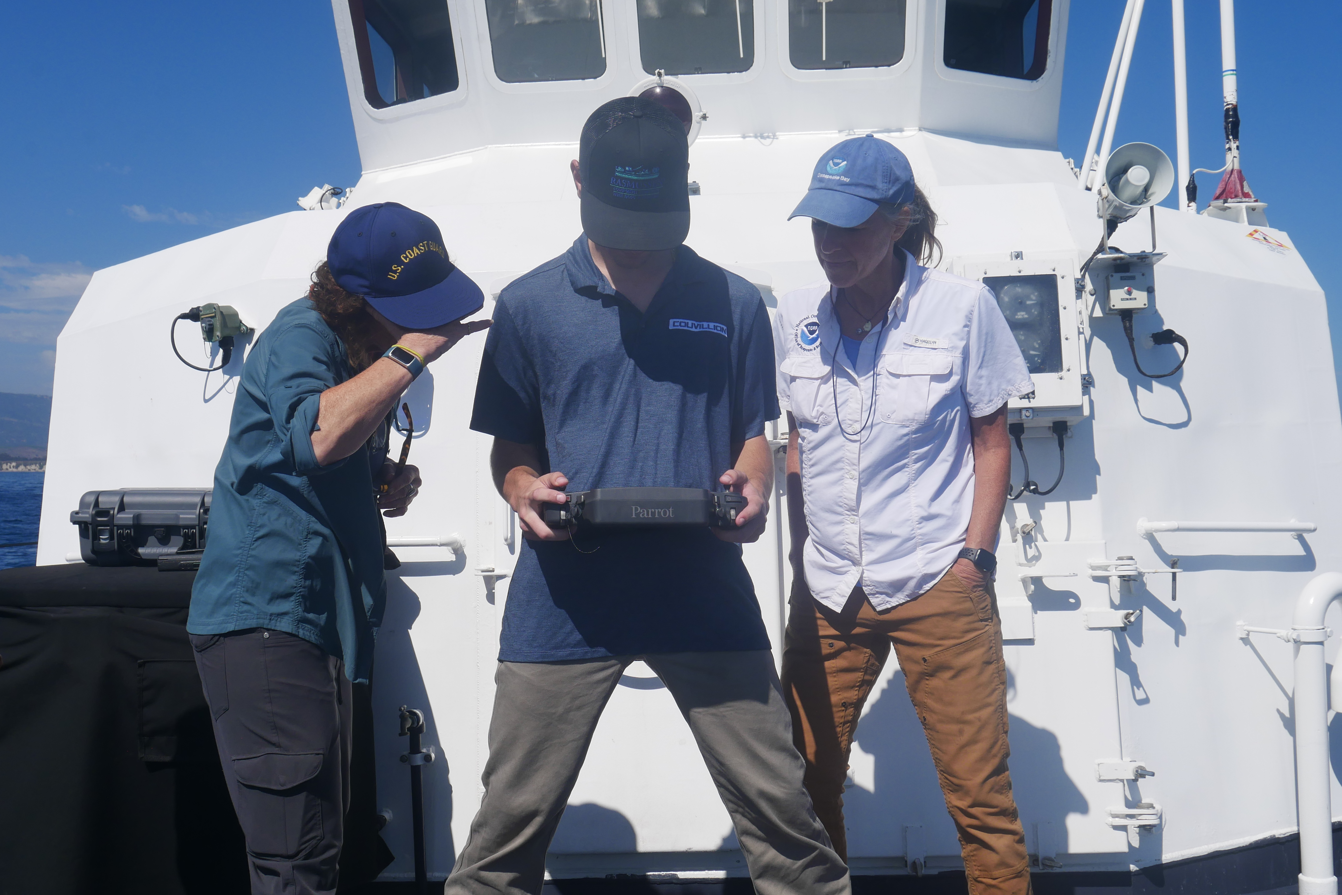
For lesson one, the instructors trained the pilots on the chemical properties and behavior of oil in water, safety procedures, preparing flight plans, and the choreography of flying drones. The oil detection mission begins with the UAS team which is made of three key roles: a USCG UAS pilot in command (PIC), a visual observer (VO), and a Captain of the vessel (along with other support CG response personnel).
For each drone flight, the Captain of the vessel and CG personnel are responsible for safe transport to and from the scene. The PIC and VO are responsible for documenting the incident. The PIC is in charge of flying safely, detecting oil, mapping oil, and landing safely. The VO is a pilot’s right hand guide, responsible for ensuring the pilot operates safely by avoiding close proximity to any manned air traffic or other hazards. The main duties of the VO are communicating the drone location, altitude, and direction of the flight as well as communicating with the vessel Captain and other involved personnel on the progress of the flight.
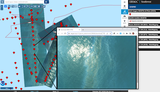
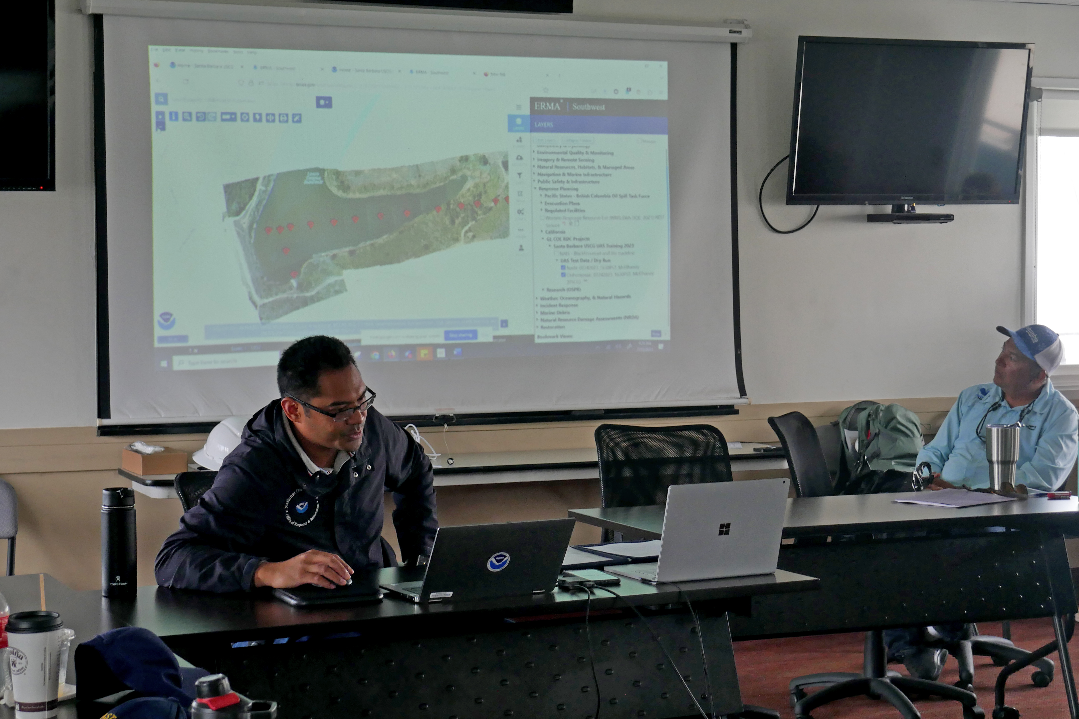
For lesson two, the instructors provided an overview of OR&R’s data management softwares, Data Integration, Visualization, Exploration, and Reporting (DIVER) and Environmental Response Management Application (ERMAⓇ). DIVER is a data warehouse that can provide responders, trustees, stakeholders, and the public with the ability to access, query, visualize, and download environmental data. DIVER is a necessary platform to manage the data collected from the pilots and drones. ERMA is an online mapping tool that can integrate data from DIVER and other partner sources in a centralized and easy-to-use format that can be viewed and utilized by environmental responders and decision-makers. ERMA serves as the official Common Operating Picture (COP) for the USCG for all response sites. ERMA aggregates various data across a location and displays it in a single map view.
It is important to have a COP such as ERMA, where everyone can see the same information displayed. During an emergency response effort, remote staff, such as those in the command post or providing support from other remote locations, can access the data uploaded to DIVER to create orthomosaic maps (maps that ‘stitch together’ a series of overlapping images captured by the drones), then upload the generated mosaic image map into ERMA. DIVER is used to process the collected imagery by providing the metadata and geolocation for the photos. The orthomosaics, photos, and videos are available for sharing in DIVER and visualization in ERMA in near real time to provide the response team updates, even while staff are still on the vessel.
In summary, DIVER collects critical pieces to an emergency event and ERMA puts these pieces and more together on a map to tell a story. As a result, responders can view the data from the drone flight along with other environmental data to make better informed decisions. A common and practical use of these softwares is to map oil and identify sensitive environments that may be at risk of injury, such as the location of at-risk marine mammal habitats. Side photo (above): OR&R’s Spatial Data Branch’s Information Analyst and Data Manager, Mike Greer, instructing UAS pilots on use of Environmental Response Management Application (ERMAⓇ).
After the classroom portion of the training, day one concluded with test flights. The class of pilots practiced flying drones from land, capturing images and videos above a reservoir, and uploading the collected data onto DIVER and ERMA in a timely fashion. Practicing on land equipped pilots for more complicated flights from a USCG response vessel out at sea during the remaining days of the training.
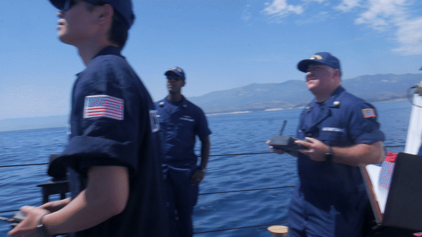
On day two, test flights began aboard the USCG Cutter Blackfin. Of the critical team of three (pilot, VO, and Captain), the Captain began their mission first, transporting the team of pilots two miles offshore into the natural oil seeps off the coast of Santa Barbara. On arrival, the pilot and VO launched into their mission, beginning their test flights to simulate a real emergency response.
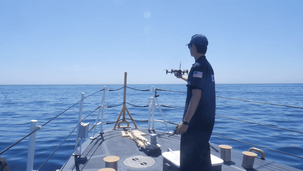
First, the pilot and VO completed a pre-flight checklist and safety protocol. The VO radioed the vessel Captain to indicate the team was ready for flight. With the Captain’s approval, the pilot waited for the VOs command before gently launching the drone in the air by hand. Using visuals transmitted from the drone’s onboard camera to the controller’s display in hand, the pilot looked for the location of the oil slick. In cases where slick was difficult to identify, the pilot turned on thermal imagery to locate oil using the differential heat storage between oil and water as an indicator.


Once the oil was located, the PIC positioned the drone to capture images that overlapped in coverage, ensuring each image captured 50% of the previous image. In some cases, the oil is easy to identify and map in one flight. When the oil slick is located farther from the launch point, the VO must radio the Captain and direct the vessel towards the slick while the drone is still in flight. When the oil slick had been fully mapped, the pilot returned the drone to the vessel and once cleared for landing, completed the flight.
Aboard the vessel, the pilot began offloading the drone’s data and uploading it into DIVER. Once processing was complete, the data were transferred into ERMA to display in a map. To simulate the conditions of a real-world emergency incident, the goal of the training was for pilots to complete their flights and data uploads before making it back to shore. Consequently, emergency responders back on ground are then able to view, access, and analyze critical information instantaneously without having to travel to the incident themselves.
After a successful mission on day two, the team debriefed on land to identify and resolve any challenges encountered while flying, uploading data, or producing maps. For the remainder of the week, teams of five or more pilots repeated the cycle, putting their practice into action.
The Power of Uncrewed Aircraft Systems
The project resulted in 15 trained pilots that are equipped with advanced expertise to utilize drones to support U.S. Coast Guard environmental missions.
There are many advantages to using UAS imagery and data in tandem with OR&R’s DIVER and ERMA platforms for emergency responders. First, responders can rapidly respond to collect data using the small, commercially available drones to view the entirety of an incident; second, data collected can be rapidly uploaded and displayed in the COP, oftentimes with one mapping product versus depending on various photos and videos pieced together. Third, drones with thermal imagery can help locate an oil slick quicker. Lastly, optimizing collected data can improve the efficiency of the response and the accuracy of subsequent fate transport models, which inform responders on how spilled oil might change and move through the environment. More accurate mapping products help responders deploy limited response resources, such as oil booms and skimmers, to reduce harm to the environment and clean up areas where oil is heaviest.
“This is the first UAS training dedicated specifically to one of the USCG missions —standardizing the process and furthering the use of cutting-edge science across the USCG for oil detection, characterization, data collection, and near real time downloading of the data in DIVER and ERMA, our Common Operating Picture, to expedite site response,” said USCG Director of Emergency Management Ms. Dana Tulis. “The guidelines will also be the first USCG Addendum to the USCG SR-UAS Flight Operations SOP, for all USCG pilots to follow for the Maritime Environmental Response mission.”
Data collected from drone flights enable responders to document and access a real-time picture of where spilled oil is located. The quality of collected data is key to a long process of disaster response and recovery. These first steps in the emergency response process inform a series of actions beyond immediate oil cleanup, including oil fate and transport modeling, support for natural resource damage assessments, and ultimately environmental restoration. Throughout this process, drone data is utilized across divisional boundaries and key stakeholders, including within OR&R, from the work of SSCs within OR&R Emergency Response Division to the damage assessment work of OR&R’s Assessment and Restoration Division and the Damage Assessment, Remediation, and Restoration Program (DARRP) and even to organizations, like the trustees entrusted with the resources.
As risks of oil spills and chemical incidents rise due to climate change, the partnership between OR&R and the U.S. Coast Guard will continue to be vital to responding to these emergencies, equipped with the data, tools and cutting-edge science necessary to respond as efficiently and effectively as possible.