
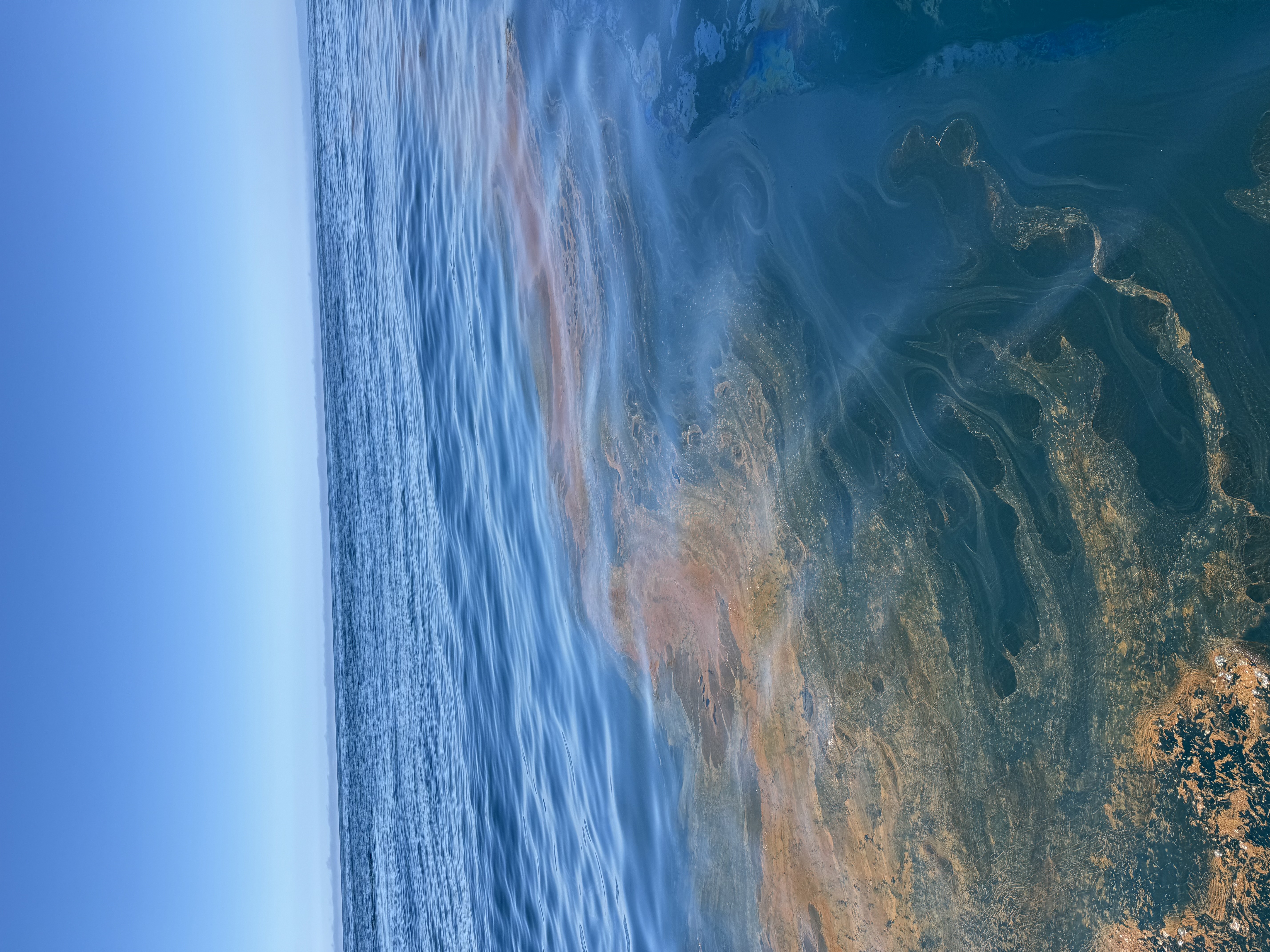
Thick brown oil pools on the surface of the ocean. Following right behind is a trail of smooth, shiny, reflective water, resembling a path of slime left behind by a giant snail. You look around and there are patches of bubbly, brown gunk and thin, rainbow disks of oil around you. Something is off and some questions naturally arise: Where is the oil coming from? Where is it going? Is it safe for the environment and wildlife? How do I get rid of it? How does the environment recover?
This is exactly what NOAA Office of Response and Restoration (OR&R) scientists, modelers, response, and damage assessment teams are asking when they respond to a spill. OR&R is a leading expert in preparing for, evaluating, and responding to threats to coastal environments, including oil and chemical spills. During pollution events, OR&R springs into action to inform and collaborate with its emergency response partners at the U.S. Coast Guard (USCG) and affected states on how to characterize and clean up a spill as well as reduce its impacts to people and the environment. This scientific support looks like: identifying the oil source, developing predictive models on the movement of oil, understanding the impacts of hazardous materials to wildlife and coastal communities, and informing the appropriate clean-up method. OR&R also works with state, federal, and tribal partners to assess impacts to public natural resources and provide restoration that makes the environment and public whole after spills and other coastal hazards.
Cleaning up an oil spill and restoring the environment boils down to the science. Scientists, data managers, and emergency responders from OR&R, the Coastal Response Research Center (CRRC) at the University of New Hampshire, U.S. Coast Guard, University of Michigan, Coastal Monitoring Associates, Water Mapping, Environmental Protection Agency, State of California, and the U.S. Navy partnered to advance oil spill science using the natural oil seeps off the coast of Santa Barbara as their ‘lab’. Their research is enhancing spill responders’ ability to respond to and assess the impacts of oil in the environment.


The Hypothesis: What Are We Testing?
Spilled oil in water is a tricky business. Think about any home project. Different tools will be used for a kitchen renovation, a plumbing problem, or an electrical issue. The same is true for oil spills. A “one size fits all” solution doesn’t exist. Environmental factors, like wind and currents, can impact the spilled oil by dispersing the oil, mixing the oil up in the water column, or moving the oil from one location to another. Biological factors, like the type of wildlife present, can influence clean up methods and response tactics. As a leading scientific expert of spill response, OR&R works to ensure that our research and methods are up-to-date to support efficient and effective spill response.

OR&R has invested significant time and resources, in partnership with multiple agencies and institutions, to develop and test innovative tools and methods that can advance our ability to better respond to and assess the impacts from oil in the environment. Transitioning these novel tools and methods from research into actual application during an event, however, can be challenging. By performing research field trials on three new technologies in concert – MetOcean Stokes Drifters (drifters), the DeepTrekker remotely operated vehicle (ROV), and the Drifting Exposure and Effects Assessment Ring (DEEAR) – along with traditional oil sampling and uncrewed aircraft systems (UAS), OR&R can better understand the value of these assets, test their efficacy, and prepare to use them during a real-world incident.


Experimenting Offshore of California
In Santa Barbara, California, there are natural oil seeps several miles offshore, which have been used for testing technologies considered for use in actual oil spills. It was in these oil slicks that the project team gathered to scale up testing of promising technologies to support OR&R’s oil spill response and assessment missions. Three sidekicks were called on to support the research: fishing charters Fin Addict and Loose Cannon and the USCG Cutter Blackfin. It is common to see multiple vessels operating in concert during an actual oil spill incident. Over two days, the primary research teams, led by OR&R and the CRRC, went aboard the Fin Addict and Loose Cannon to perform experiments, working in two different offshore areas: a test area (water with oil from the natural seeps) and a control area (unoiled water).
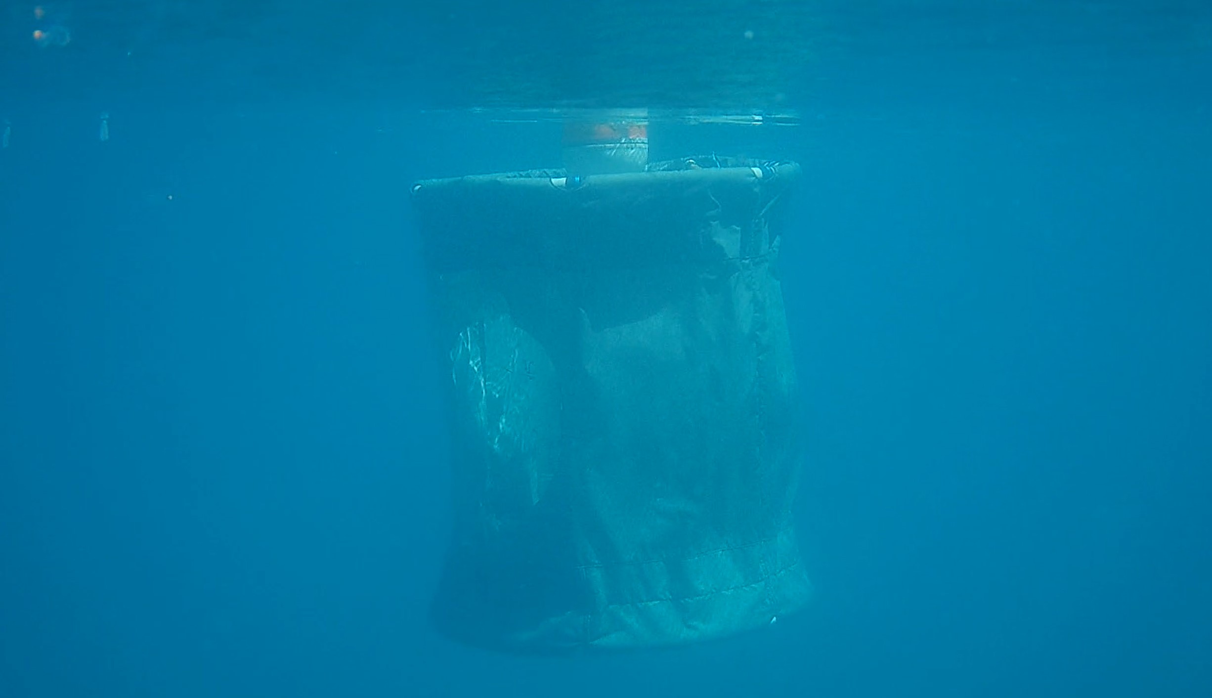
On day one, the team on the Loose Cannon motored a few miles offshore and deployed in the open ocean two DEEARs, a portable bioassay system designed to move with water currents and assess the toxicity of oil slicks and sheens to aquatic organisms in the underlying water. The DEEAR units have a ring of exposure chambers suspended within it that are loaded with young fish and shrimp. When deployed, the surrounding seawater is pumped through the DEEARs’ chambers as the unit drifts with oil, mimicking how planktonic wildlife move in the water and are exposed to oil just beneath the surface oil slicks. The unit also contains an array of water quality sensors including a fluorometer and passive sampling devices to characterize oil exposure. The two DEEAR units were deployed and left out at sea for 24 hours; one was deployed under surface oil slicks but drifted out of the oil and one was deployed in the unoiled control area for comparison. Drones, or UASs, were flown above the water to identify large patches of oil to deploy the test DEEAR in and to characterize the surface oil (e.g., thickness, patchiness, degree of weathering).
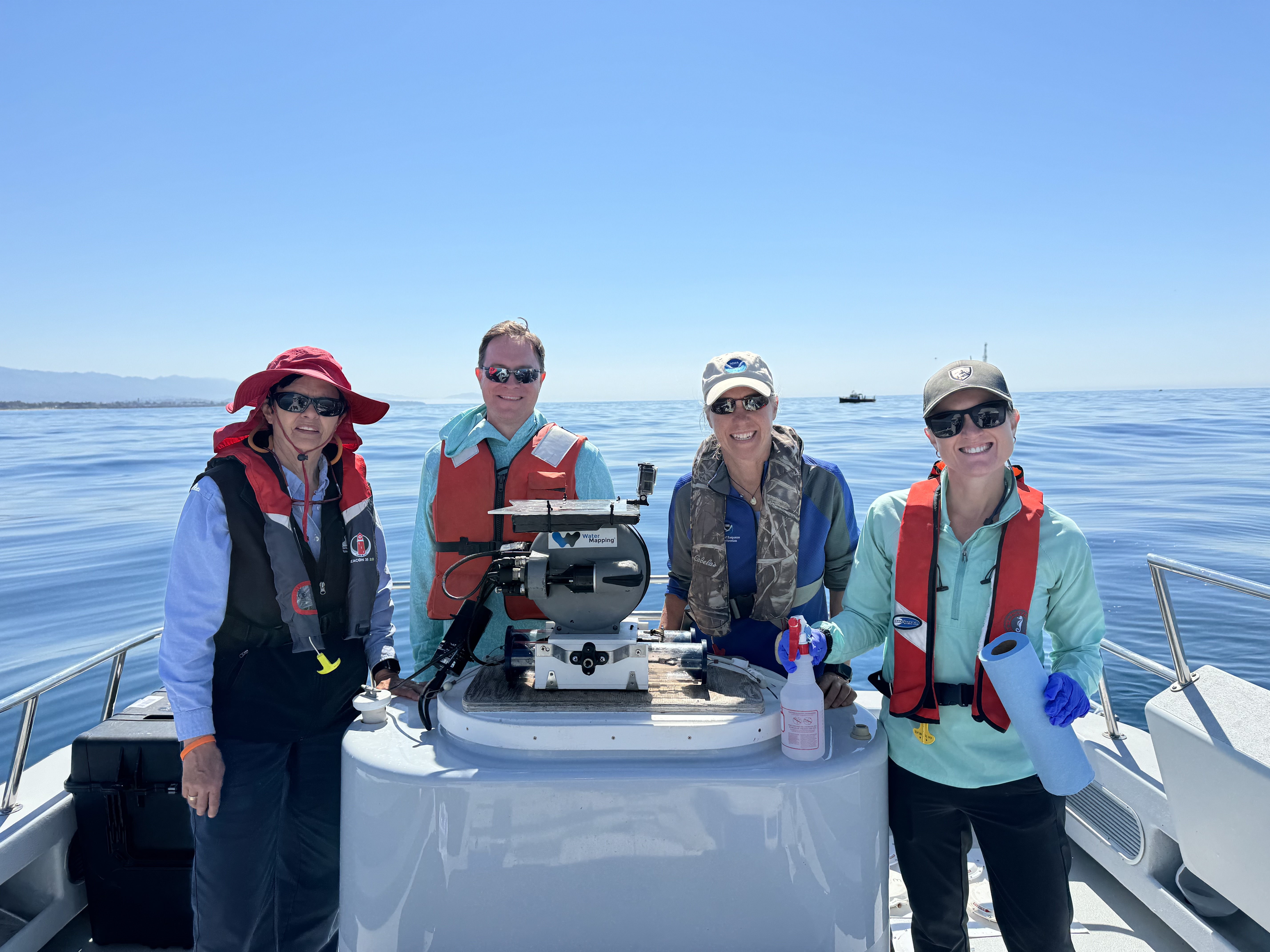
Simultaneously, the team on the Fin Addict followed close behind, deploying the ROV to take water samples at the deployment sites of each of the two DEEAR units. Team Fin Addict also collected ‘source oil’ samples from the floating oil for chemical analyses back on land. Afterwards, Team Fin Addict began testing the MetOcean drifters—flat buoys designed to float and drift with surface oil slicks. Ten drifters were deployed in a stretch of surface oil that was identified and mapped by drones from the Loose Cannon. These drifters, designed to transmit data even with oil coating their surface, were left to float with the oil overnight and tracked with near-real time GPS.
On day two, the teams on the Loose Cannon and Fin Addict set out to retrieve the DEEAR units and MetOcean Drifters that were out at sea overnight. The location of each tool was tracked through the night up until the time of retrieval and tracking data was shared with OR&R’s data management team. The two DEEARs and ten MetOcean Drifters were retrieved successfully, with the help of the USCG aboard the Cutter Blackfin. After retrieval, the DEEAR organisms are returned to a lab onshore and evaluated for toxic effects from oil exposure.
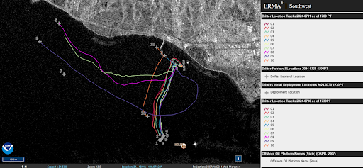
Field Work at Our Fingertips: Data Management, Coordination, and Monitoring
Over these two days of research, OR&R, CRRC, and their partners provided remote support to track the deployed technologies, manage data collected by the field teams, and provide routine communication “on shore,” simulating the response efforts during a real-world incident. OR&R’s data management team collected, tracked, uploaded data and documents to the DIVER (Data Integration, Visualization, Exploration, and Reporting) tool, and displayed data in-sync in the Environmental Response Management Application (ERMA®). DIVER is used as the data warehouse and repository of the environmental data and documents. It serves as a collaborative space for information and data, data management, and data exchange. Data and documents loaded include the safety and float plans, data management plan for the project, field forms, sample forms, GPS information, photos, and more. ERMA is the designated Common Operating Picture (COP), a single display of the data collected during the life-cycle of an incident. ERMA compiles data collected from different operators, technologies, and timeframes and displays it into one single platform. From the testing, ERMA displayed the locations of the oil slicks, vessels, MetOcean Drifters and DEEAR units deployment locations, USCG UAS data, water sampling locations, and satellite imagery.
The Big Deal: The Role of Technology in Oil Spill Response
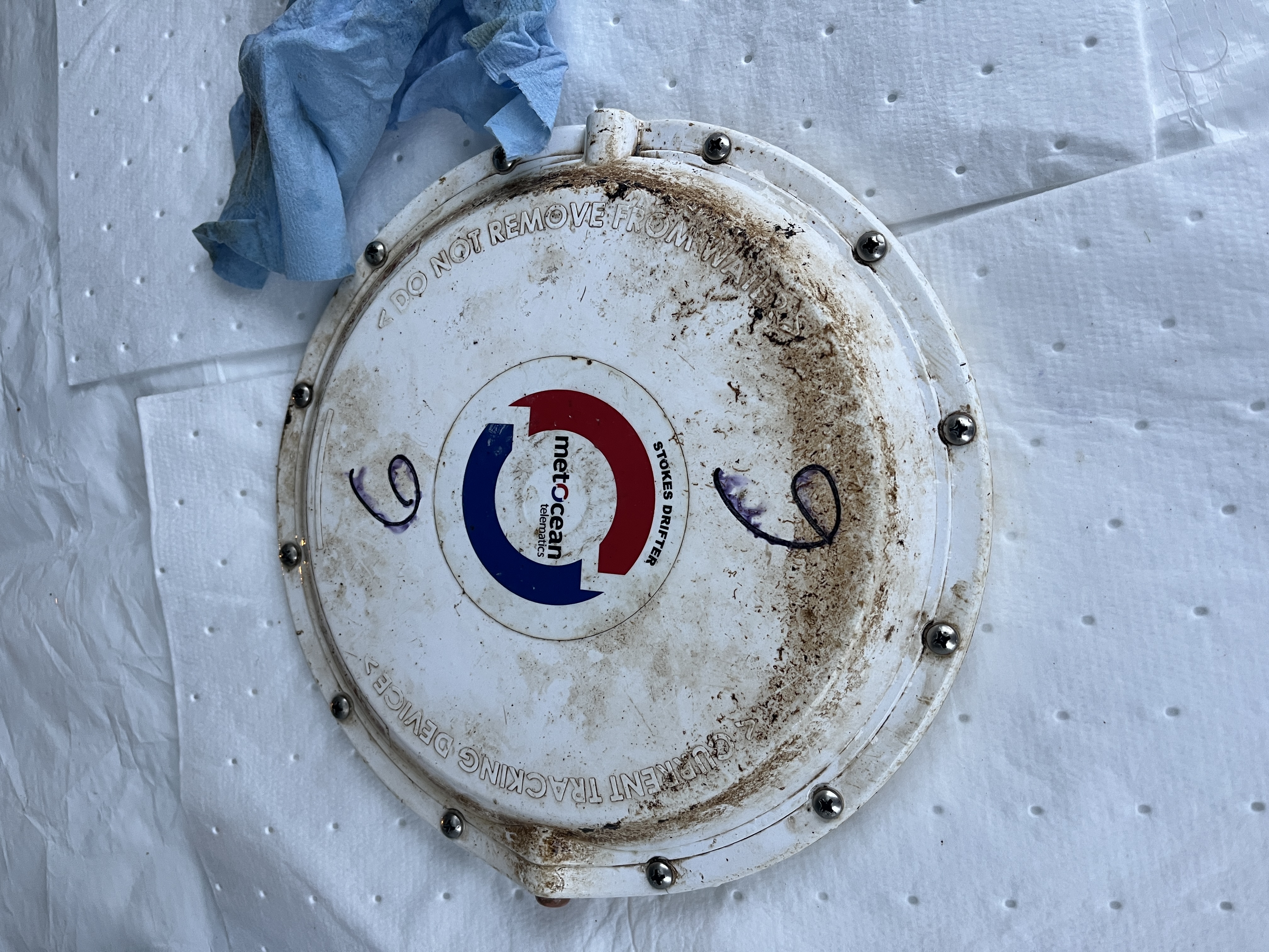
What’s the catch with these technologies? For starters, the MetOcean drifters are relatively novel tools for oil spill science. The drifters are an advanced version of a drifting buoy. They are compact so they are easy to use and deploy during an oil spill recovery effort. Furthermore, they are equipped with an activation magnet that enables them to be dropped from a height of 10 meters and transmit accurate geographic and environmental data in real-time. During an oil spill, one of the most important questions OR&R emergency responders try to answer is, ‘where is the oil going’ and data from the drifters can make models and predictions more accurate and useful for an effective response.
The DEEAR system was first developed and tested in 2018 by a team of scientists from OR&R, the University of Michigan, Coastal Monitoring Associates, and the Naval Information Warfare Center Pacific. The objective was to directly assess oil exposure and resulting toxic effects in the ocean, rather than relying only on laboratory toxicity tests that may not mimic the amount of oil exposure animals experience in marine environments. Since this first test, the DEEAR was modified so that the organisms in the exposure chambers undergo exposure to ultraviolet (UV) radiation in the same way that organisms do in the water column of the open ocean. This modification is important as exposure to sunlight exacerbates the toxicity of oil. In fact, UV exposure can make oil as much as 100 times more toxic to aquatic organisms so this modification better represents real-life conditions. The DEEAR was also fitted with more water sampling tools to characterize how much oil organisms are exposed to and for how long.
Ultimately, this continued testing of technologies provides researchers with a better understanding of the impacts of open water oil spills and how to respond to them.
A Sneak Peek at the Results
This deployment test of the DEEAR, MetOcean Drifters, and ROV aimed to assess the ability of the technologies to identify, characterize, and track surface oil and quantify the toxicity of oil spills to marine life. Regarding the DEEAR results, organisms that were in the unit that was deployed in the oil showed toxic effects from relatively short duration and low concentration oil exposure, confirming and expanding on previous field tests. Furthermore, the chemistry data provided both time-series and cumulative oil exposure information and showed a difference in exposure levels at different depths under surface slicks and sheens. Regarding the drifters, testing was also successful. Each drifter transmitted GPS data every five to ten minutes and provided an accurate trackline, or path, of the movement of oiled water that could be integrated into oil trajectory modeling.
What does this tell us? First, the DEEAR data validates and refines the team’s earlier work, confirming that the DEEAR is a reliable tool to assess the toxicity of oil to aquatic organisms in the open ocean. This round of testing provided valuable refinements in test animal selection and care, demonstrated the importance of including realistic sunlight exposure, and added to our understanding of how organisms are exposed to oil in the water under surface slicks. The technology could be used to support future injury assessment work for oil spills and the data bolster our understanding of how many early life stage fish can be impacted by oil exposure. This data informs assessment of both the immediate and long-term effects of oil spills. Lastly, researchers now have a better understanding of the use of drifters. During an actual incident, NOAA modelers will be able to track the drifters’ movement as it moves with a spill and use this information to provide updated fate and trajectory models.


Looking Ahead to Future Oil Spill Response
Of the 162 total incidents that OR&R supported in 2023 alone, 132 were oil spills. Oil spills are more common than you might think and they happen in many different ways. Whether big or small, these spills can threaten life, property, and natural resources. As such, it is of the utmost importance that OR&R is armed with technology, methods, and expertise to effectively support oil spill response, assessment, and restoration.
OR&R’s science team is critical to emergency response and damage assessment. Our on-the-water research advances how information from multiple platforms is received, interpreted, and shared with spill responders, trustees involved in the damage assessment, and communities. Preparing new tools, technologies, and methods to be utilized during a future real-time oil spill event is essential to improving overall spill response and recovery efforts. As a result of this research focused on operationalizing newer technologies, OR&R will be better equipped and prepared to help clean up an oil spill, minimize the harm to wildlife and coastal communities, and restore impacted natural resources.
This project was funded by OR&R and USCG, and made possible by a partnership between NOAA’s OR&R and the Coastal Response Research Center at University of New Hampshire. Additional agency funding will continue this effort in preparing novel tools to be tested in a potential spill of opportunity.