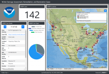
Keeping up with technology is no small task. It seems like every month our smartphone software is out of date or there are some big updates happening on the computer. Nowadays, many smartphone apps will automatically refresh themselves with the most recent version. These range from small security fixes to major updates with a new look or feel that can catch users off guard. Just like any other technology, NOAA tools need to be updated so our work can continue to go as planned.
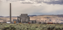
Flowing through southeastern Washington is an approximately 50 mile stretch of the Columbia River known as the Hanford Reach. This unique section of the river is an important habitat for fish and wildlife, including Chinook salmon. This area also served as the birthplace of the atomic bomb at the Hanford Nuclear Reservation.
By Megan Ewald, Office of Response and Restoration
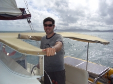
This feature is part of a monthly series profiling scientists and technicians who provide exemplary contributions to the mission of NOAA’s Office of Response and Restoration (OR&R). This month’s featured scientist is Ben Shorr, a physical scientist in OR&R’s Assessment and Restoration Division.
By Megan Ewald, Office of Response and Restoration
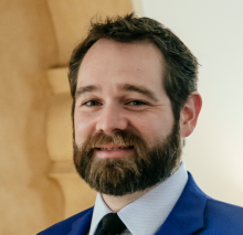
This feature is part of a monthly series profiling scientists and technicians who provide exemplary contributions to the mission of NOAA’s Office of Response and Restoration (OR&R). This month’s featured scientist is Jason Murray, an environmental economist in OR&R’s Assessment and Restoration Division.
By Alyssa Gray, NOAA's Office of Response and Restoration
This is the eighth in a monthly series profiling scientists and technicians who provide exemplary contributions to the mission of NOAA’s Office of Response and Restoration (OR&R). This month’s profile is on Assessment and Restoration Division toxicologist and Alaska Regional Resource Coordinator Sarah Allan.
By Robert Neely, NOAA’s Office of Response and Restoration
On April 22, 2018, a team of people from a diverse suite of organizations from within and outside of NOAA began packing and loading gear, trailering and cleaning boats, and wrapping up preliminary paperwork. Made up of field biologists, toxicologists, injury assessment specialists, data managers, and field technicians, the team had just completed a week in the field as part of a major study to help determine the impacts to Endangered Species Act-listed juvenile Chinook salmon from exposure to contaminants as they out-migrate through the Portland Harbor Superfund site via the Willamette River.
By Amanda Laverty, Office of Response and Restoration Marine Debris Program
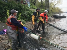
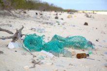
Marine debris and plastic pollution first appeared in scientific literature in the 1970s, and have since become highly published topics. Debris can be found in a variety of marine environments — from coasts and remote beaches, to Arctic and Antarctic regions — throughout the open ocean and all the way down to the deepest depths of the sea floor.
Our first day of surveying intertidal habitats on the Farallon Islands was cold and wet, with gusty winds practically blowing us over while we set out our sampling plots. The Farallones, 29 miles west of the Golden Gate Bridge in San Francisco, are a desolate cluster of seven small rocky outcrops sometimes dubbed the “Devil’s Teeth,” but other times referred to as “California’s Galapagos.” The jagged rocks are barely visible over the western horizon from the Golden Gate, but on a clear day can be seen from the more northerly Point Bonita lighthouse as gray spikes poking through an otherwise flat and expansive sea surface.
Annie Gibbs, NOAA Office of Response and Restoration
The St. Louis River/Interlake/Duluth Tar site was used for a variety of industrial purposes — including coking plants, tar and chemical companies, the production of pig iron, meat-packing, and as a rail to truck transfer point for bulk commodities — starting near the turn of the 19th century. In 1983, the St. Louis River Superfund site was added to the National Priorities List.
In November of last year, a settlement was reached between the trustees for the site and the parties responsible for the contamination. The settlement includes funds for the following restoration projects ...
By Alyssa Gray, NOAA's Office of Response and Restoration
The story behind the Sheboygan River and Harbor Superfund site began in the 1870s, when growing industrial activity along the river led to a release of contaminants, including polychlorinated biphenyls (PCBs), heavy metals, and polycyclic aromatic hydrocarbons (PAHs).
In 1979, the State of Wisconsin began advising the public against eating any resident species from the Sheboygan River, and only limited consumption of fish species from Lake Michigan, where the Sheboygan empties.